Extreme heat has descended on the tri-state.
The danger level is high, as we get some of the worst heat we’ve felt in years. It won’t be until later this week that relief comes our way.
Part of what makes the heat feel so oppressive is the fact that our bodies are not acclimated to it. Temperatures in May and early June have been mostly below average, so this week’s heat comes as a shock to our bodies.
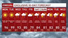
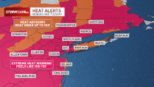
Our high temperatures through Wednesday will stay above 90, peaking at 100 degrees on Tuesday. These highs will break records in many places across the tri-state as multiple spots on the map climb into the triple digits. And that is before considering the heat index, or “feels like” temperature. Check latest weather alerts here.
The heat index communicates what a given temperature will feel like by taking into account the dew point, which is a measure of the amount of moisture – or humidity – in the atmosphere. The higher the dew point, the higher the humidity and the higher the feels like temperature. Tuesday’s afternoon’s dew points are about as high as we ever see in this region.
When the humidity is high, our bodies’ natural air conditioning system – sweat – does work well. We cool ourselves on hot days by evaporation of sweat, which pulls heat away from our skin and keeps our body temperature in check.
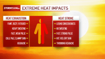
On humid days, sweat doesn’t evaporate. Instead, it just collects on our skin, and our bodies can’t cool off. That dramatically increases the risk of heat exhaustion and even heat stroke.
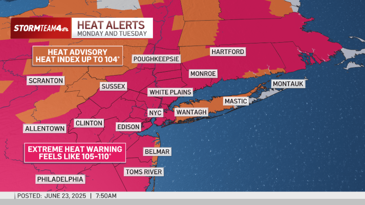
The National Weather Service has issued extreme heat warnings and heat advisories for nearly the entire region because of heat index readings well into the triple digits. Significantly limit your heat exposure while the heat alerts are in place.
Though “heat” is something we face every year, it is the single most dangerous form of severe weather, responsible for more deaths than even flooding.
Part of what makes this wave of heat so dangerous, aside from the fact that it is coming so early in the season, is how unrelenting it is. We talk a lot about the high temperatures and the heat indices, which are brutal, but the overnight low temperatures are incredibly warm as well. We’re looking at several days where our low temperatures will be staying in the 80s.
Wednesday morning’s low is forecast to be 81… that is just about what the average high temperatures is for this time of year.
A large area of high pressure parked over the eastern half of the country is the culprit for this week’s heat. When a high-pressure system stalls over a given region it acts as a heat pump, fueling a drastic and sustained rise in temperatures. Think of high pressure like a lid on a pot. Surface temperatures heat up and as that air starts to rise, high pressure seals it over that region. Then when that hot air sinks back down, it compresses and reheats, keeping that heat locked in place, often until a strong front or a shift in the jet stream moves it along.
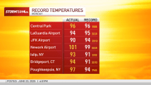
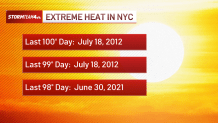
We’ve encountered heat domes and heat waves before, but this particular level of heat is something we have not seen in the Tri-State for quite some time. Temperatures reaching the triple digits don’t happen very often around here. Despite some impressive heat over the past few years. Central Park has not seen 100 degrees since 2012. So it has been well over a decade since we’ve experienced temperatures this hot. You even have to go back 4 years just to find the last time Central Park hit 98.
It is not until late Wednesday and into Thursday that we finally see the heat dome moving offshore, weakening its influence on our area. And with high pressure out of the way, a stormy summertime weather pattern takes hold of the forecast. We’ll be in and out of storm chances for most of the second half of the week, continuing into the weekend. It is not going to be non-stop, but anything that develops, especially on Wednesday, could become strong to severe.
And more showers and stormy weather may not exactly be what we want after the spring we just finished. But if there is one good thing to come from these storms it is a cooldown. It won’t be a dramatic change, but we will be more than happy to welcome highs back into the 80s. And if you’re really craving cooler temperatures, Friday’s high only in the mid 70s is probably closer to what you were hoping for.
Unfortunately, it is just the one day in the 70s before we are back into the mid-80s, which may sound okay right now, but that is still largely considered above average for this time of year.
It’s still the beginning, but this summer is off to quite the hot start. Take care of yourself and your loved ones over the next several days. Stay hydrated and stay cool. We still have a long season ahead of us.
10-day NYC weather forecast