NEW YORK – Heat and thunderstorm warnings remain in effect throughout the New York City Tri-State, but is this worst over? Here’s a look at the forecast after the area suffered through feels-like temperatures over 100 degrees, followed by fast-moving thunderstorms.
JUMP TO: WEEKEND FORECAST
Today’s heat
What we know:
The Northeast is experiencing a sweltering heatwave, with temperatures soaring and humidity levels rising, leading to summer-like thunderstorms across the region.
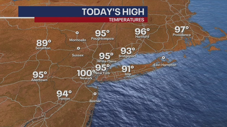
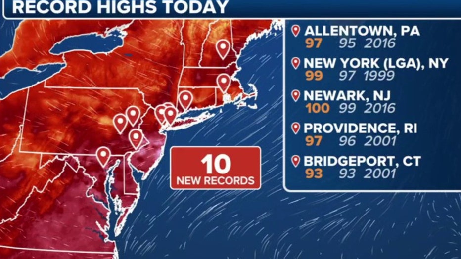
On Friday, New York City saw temperatures climb to 95 degrees, nearing the record high of 97 set in 1999. The “feel-like” temperatures were even more intense, reaching between 105 and 106 degrees, creating challenging conditions for residents.
High temperatures on 7/25/2025 (FOX Weather)
Other areas in the region also faced extreme heat, with Newark hitting 100 degrees and Trenton recording 94 degrees.
And the suffering doesn’t stop here – the Southeast is similarly affected, with cities like Atlanta and Memphis experiencing temperatures of 92 degrees, New Orleans at 93, and Dallas reaching 98 degrees. Washington D.C. and Boston reported temperatures of 96 and 95 degrees, respectively, as the heatwave extends throughout New England and the Northeast.
Fast-moving thunderstorms
Relief from the heat came in the form of showers and thunderstorms, which traveled ahead of a cold front, temporarily cooling temperatures to 82 degrees in New York and 84 degrees in Long Island. However, the humidity remains high, with dew point temperatures in the low to mid-70s, ensuring a muggy atmosphere persists.

A lightning strike in Brooklyn, New York on July 25, 2025. (Alex Hall)
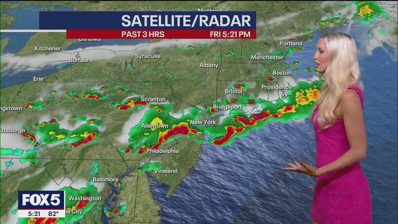
Satellite radar imagery shows storms forming an organized line, impacting parts of Massachusetts and Rhode Island. There is potential for isolated thunderstorms in Nassau County and New Jersey, with temperatures remaining in the 80s tonight, clearing by 8 or 9 p.m.

Wind speeds are consistent at 5 to 15 mph, although strong gusts have been reported, causing delays at Newark Airport.
What’s next:
FOX 5 NY‘s Liv Johnson predict a brief respite from the humidity this weekend, with dew points expected to drop to the 50s by mid-afternoon before rising again by Saturday evening.
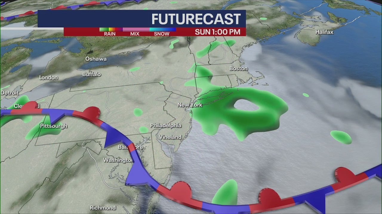
Looking ahead, Saturday will start in the upper 70s, reaching mid-80s by midday. A quick shower is possible Saturday night, followed by thunderstorms on Sunday.
 More heat on the way
The heatwave is expected to continue into next week, with temperatures already forecasted to be in the 90s, accompanied by high humidity levels.
Residents are advised to stay hydrated, seek air-conditioned environments, and remain vigilant for any weather updates as the region navigates this extreme summer weather pattern.
The Source: This article uses reporting from FOX 5 NY’s Liv Johnson’s forecast.