Governor Bob Ferguson said the state requested emergency support from the federal government and FEMA, and that he had spoken directly with President Donald Trump on the phone.
Official Evacuation Information and map from Spokane Regional Emergency Communications: Click Here
See Stevens County evacuation information here: Stevens County Public Information Map
SPOKANE, Wash. – Hundreds of homes were lost in a series of fires that broke out in the Spokane area in the afternoon of August 1.
First responders mobilized quickly on three fires, the Old Trails Fire north of Airway Heights, Autumn Lane Fire near Five Mile Falls and the Fairview Fire near Mead.
A “particularly dangerous situation” alert was set for Saturday for red flag conditions in the region that helped the fires grow to thousands of acres Saturday.
Evacuations were issued for many homes in the area, and crews worked throughout the night to protect structures.
You can find the latest information on the fires, now being managed as one named the Spokane Area Fires, below.
UPDATE: August 2 at 11:20 p.m.
Spokane County Fire District 9 said crews are working in the Painted Rocks area along Rutter Parkway as the Autumn Lane fire has moved into that area.
The district said the fire made a major move downhill and reached Rutter Parkway.
People are urged to stay off Rutter Parkway. Fire engines, law enforcement and other emergency vehicles are operating throughout the area and need the road kept clear for emergency work.
The area was already under a Level 3 evacuation, meaning people needed to leave immediately and stay out of the area.
UPDATE: August 2 at 10:30 p.m.
The Mann-Grandstaff VA Medical Center announced it’s closed due to the wildfire evacuation zone affecting the campus and surrounding neighborhoods.
The center said evacuated veteran patients are under the care of local partnering hospitals.
VA clinics across Spokane including locations in Spokane Valley, E. Front Ave., 2nd Ave., Wall Street, and the Mayfair building are also closed through at least August 3rd and 4th.
Veterans needing pharmacy or crisis support can call 800-507-4571 for the National Disaster Veterans Hotline or 988 for the crisis lifeline.
UPDATE: August 2 at 10:22 p.m.
Fairchild Air Force Base has issued a limited evacuation order for military personnel, civilian employees and their families living in Level 3 evacuation zones.
Col. Brian Epperson, 92nd ARW commander, said the base is mobilizing every available resource to provide safe lodging and support for those displaced.
Families needing immediate assistance can visit the Emergency Family Assistance Center at the Red Morgan Center, open daily from 8 a.m. to 8 p.m.
UPDATE: August 2 at 8:30 p.m.
Fairchild Air Force Base announced that it has opened its Emergency Family Assistance Center to help service members, Department of the Air Force civilian employees and families affected by local wildfires.
The center operates out of the Red Morgan Center each day from 8:00 a.m. to 8:00 p.m. The base said anyone with base access could go there for help, although some services depended on a person’s status.
Support at the site includes emergency referrals, financial assistance resources, family support services and community updates.
The base also said people with base access who wanted to help could volunteer or bring donations to the Red Morgan Center. Accepted items included bottled water, toilet paper, socks, first aid kits, new packaged underwear, feminine hygiene products, pet food, paper plates, napkins, cutlery, toiletries, baby wipes, diapers and laundry soap.
The base said it could not take donations from people without base access at this time.
UPDATE: August 2 at 8:25 p.m.
Due to the ongoing wildfires, the concrete repair project on eastbound I-90 west of Spokane that was set to begin Sunday, Aug. 2 has been postponed, according to Washington Department of Transportation (WSDOT).
Eastbound I-90 and the US 2 ramp to eastbound I-90 will remain open while WSDOT reassesses resources to determine a new start date.
UPDATE: August 2 at 7:30 p.m.
MultiCare announced Deaconess and Valley Hospitals will remain open and ready to serve the community during this difficult time.
However, three MultiCare locations — MultiCare Emergency – Deaconess North on N. Division Street, MultiCare Rockwood Primary Care – Northwest Spokane on W. Lowell Ave, and the MultiCare Cancer Institute on E. Farewell Road — will be closed Monday due to evacuation zones.
Patients affected will be contacted to reschedule at another location.
UPDATE: August 2 at 4:46 p.m.
The Federal Emergency Management Agency has approved Washington state’s request for Fire Management Assistance Grants for the Autumn Lane Fire, Fairview Fire and Sinlahekin Fire.
Gov. Bob Ferguson said the grants will provide federal financial assistance to help cover eligible firefighting costs for the Spokane Area Fires and the Sinlahekin Fire burning in Okanogan County.
The latest fire acreage estimates are:
- Old Trails Fire: 3,481 acres
- Autumn Lane Fire: 3,333 acres
- Fairview Fire: 914 acres
UPDATE: August 2 at 2:36 p.m.
Officials gave a press conference on Sunday afternoon emphasizing collaboration and unity as the Spokane Area Fires devastate local communities.
“I want the people of Eastern Washington to know that the geographic and political boundaries that separate us are invisible today,” Brown said. “We are pulling together. We are here for you.”
Congressman Michael Baumgartner echoed that sentiment.
“This is not Republicans and Democrats you see before you, it’s concerned elected officials who are going to do what’s right for this community,” Baumgartner said.
Governor Bob Ferguson said the state has requested emergency support from the federal government and FEMA, and that he had spoken directly with President Donald Trump on the phone.
“The President was very gracious, as was Secretary Mullin,” Ferguson said. “[President Trump] expressed his support for what the people are going through out here. I deeply appreciate him taking the time.”
Mayor Lisa Brown called the fire complex “the worst natural disaster our region has faced” and Major General Gent Welsh said “Spokane woke up this morning to a tremendous tragedy.”
Sen. Maria Cantwell said during Sunday’s press conference that the Spokane Area Fires are now the nation’s top wildfire priority.
“Today, it is the top fire in our nation. That means [the federal government is] going to give us the resources that we need here on the ground,” Cantwell said.
UPDATE: August, 2 at 1:53 p.m.
Washington Gov. Bob Ferguson said he spoke with President Donald Trump and Secretary Mullen about the Spokane Area Fires.
UPDATE: August 2 at 1:35 p.m.
Forward progression has been stopped on the Fairview Fire, according to Spokane County Fire District 9. The Fairview Fire is one of multiple fires burning within city limits being referred to as the Spokane Area Fires.
“Please continue to monitor official evacuation maps for the latest notices,” SCFD 9 said. “Fire crews remain in the area strengthening containment lines and addressing hotspots.”
UPDATE: August 2 at 12:59 p.m.
According to Governor Bob Ferguson, the Department of Homeland Security has pledged full support.
UPDATE: August 2 at 12:09 p.m.
The latest acreage estimations for the three fires making up the Spokane Area Fires are as follows, according to Tom Stokesberry with the California Interagency Incident Management Team 7:
Old Trails Fire: 3,481 acres
Fairview Fire: 914 acres
Autumn Lane Fire: 3,333 acres
Spokane Fire Department spokesperson Justin De Ruyter said Sunday morning that he expected the final county of damaged structures to exceed the early estimate of 640.
UPDATE: August 2 at 11:50 a.m.
Spokane Fire Public Information Officer Justin De Ruyter said the estimate of 600 structures destroyed is a preliminary estimate and called it “low.”
“There are hundreds of primary residents that were affected within the city itself,” De Ruyter said.
UPDATE: August 2 at 11:14 a.m.
According to Betsy Robertson with the Red Cross Northwest Region, more than 400 people stayed overnight at the evacuation shelter at the Spokane Convention Center.
UPDATE: August 2 at 10:23 a.m.
Flett Middle School confirmed the campus is unharmed.
“We also know some of our families and staff are facing difficult circumstances right now,” the school wrote. “We’re working with SPS Crisis Response to understand needs and will share ways to support one another soon.”
We’ve reached out to Spokane Public Schools for information about other schools in the affected evacuation articles. As soon as new information is available, updates will be added to this article.
We’re in the Indian Trail neighborhood with a look at the destruction cased by fires Saturday.
UPDATE: August 2, 2026 at 10:05 a.m.
Avista said that it has shut off natural gas service in affected areas where it is safe to do so. However, the utility said customers may still notice the smell of natural gas because gas remains in service lines and interior piping after service is shut off.
According to Avista, the remaining gas may dissipate quickly or could remain in the lines for an extended period, depending on the system.
UPDATE: August 2, 2026 at 8:15 a.m.
The Spokane Area Fires are now estimated to be burning 5,390 acres, according to InciWeb.
UPDATE: August 2, 2026 at 7:54 a.m.
Evacuations have expanded to include additional Level 1 “Get ready” status.


Courtesy of Spokane Regional Emergency Communications
View the full evacuation map online through Spokane Regional Emergency Communications.
UPDATE: August 2, 2026 at 7:30 a.m.
The Old Trails Fire, Autumn Lane Fire and the Fairview Fire are now being reported as one complex named the Spokane Area Fires. According to California Interagency Incident Management Team 7, as many at 600 structures have been destroyed per preliminary assessments.
A shelter has been opened for evacuees at the Spokane Convention Center.
As of Sunday morning, the following areas are under level 3 evacuation for the complex of fires:
Old Trails Fire:
RUTTER ON THE NORTH. STRONG ON THE SOUTH. SPOKANE RIVER ON THE WEST. DIVISION ON THE EAST.
STRONG ON THE NORTH. FRANCIS ON THE SOUTH. SPOKANE RIVER ON THE WEST. FIVE MILE ON THE EAST.
FRANCIS ON THE NORTH. WELLESLEY ON THE SOUTH. ASH ON THE WEST. DIVISION ON THE EAST.
Level 2 evacuations for the Old Trails Fire are in place for this area:
MAGNESIUM ON THE NORTH. FRANCIS ON THE SOUTH. DIVISION ON THE EAST AND NEVADA ON THE WEST.
Autumn Lane Fire:
ALL HOUSES NORTH OF CHARLES FROM THE DAM TO BOND LN
ALL HOUSES ON THE EAST SIDE OF CHARLES FROM BOND LN TO HIGHLAND.
EAST TO CHARLES RD. SOUTH TO HIGHLAND. NORTH TO THE END OF LUPIN LN. NORTH TO 12418 W CHARLES.
LENETTE ON THE NORTH. THE END OF LUPIN ON THE SOUTH. LAKE SPOKANE ON THE EAST. WILLYNWOOD ONTHE WEST.
BERNHILL ON THE NORTH. RUTTER ON THE SOUTH. STEVENS COUNTY LINE IN THE WEST. HAZARD ON THE EAST.
BALLARD ON THE NORTH. RUTTER ON THE SOUTH. HARZARD ON THE WEST. AUSTIN ON THE EAST.
in the area of Hazard to the east, Bernhill to the south, Woolard to the north, Lincoln County line to the west.
Level 2 evacuations are in place for the Autumn Lane fire in the following area:
RIDGEWAY ON THE NORTH. AUSTIN TO THE EAST. BALLARD ROAD FROM THE SOUTHEAST AND AS IT MOVES NORTHWEST TO HAZARD AND CONTINUES WEST TO STEVENS COUNTY LINE.
Fairview Fire:
MT SPOKANE PARK DR ON THE NORTH. ORCHARD ON THE SOUTH. MARKET ON THE WEST. FORKER ON THE EAST.
PEONE ON THE NORTH. LINDGREN ON THE SOUTH. HWY 395 ON THE WEST AND BRUCE ON THE WEST.
ORCHARD ON THE NORTH. LINCOLN/PLEASANT PRAIRIE ON THE SOUTH. FORKER ON THE EAST. MARKET ON THE WEST.

SPOKANE, Wash. – Fires have several homes in the Spokane area evacuated Saturday.
Officials are telling everyone impacted that all evacuation traffic should be moving eastbound. People are asked to use side streets.
The current area is evacuated due to the Old Trails Fire north of Airway Heights as of 9:24 pm:
RUTTER ON THE NORTH. STRONG ON THE SOUTH. SPOKANE RIVER ON THE WEST. DIVISION ON THE EAST.
STRONG ON THE NORTH. FRANCIS ON THE SOUTH. SPOKANE RIVER ON THE WEST. FIVE MILE ON THE EAST.
FRANCIS ON THE NORTH. WELLESLEY ON THE SOUTH. ASH ON THE WEST. DIVISION ON THE EAST.
Level 2 evacuations are in place for this area:
MAGNESIUM ON THE NORTH. FRANCIS ON THE SOUTH. DIVISION ON THE EAST AND NEVADA ON THE WEST.

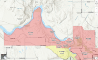
Screenshot of the Spokane County Evacuation Map taken on August 1, 2026 at 9:25 p.m.
The following area is on Level 3 evacuations due to the Fairview Fire near Mead:
MT SPOKANE PARK DR ON THE NORTH. ORCHARD ON THE SOUTH. MARKET ON THE WEST. FORKER ON THE EAST.
PEONE ON THE NORTH. LINDGREN ON THE SOUTH. HWY 395 ON THE WEST AND BRUCE ON THE WEST.
ORCHARD ON THE NORTH. LINCOLN/PLEASANT PRAIRIE ON THE SOUTH. FORKER ON THE EAST. MARKET ON THE WEST.
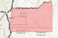
Screenshot of the Spokane County Evacuation Map taken on August 1, 2026 at 6:43 pm.
The following areas are under level 3 evacuations for the Autumn Lane Fire near Five Mile Falls:
ALL HOUSES NORTH OF CHARLES FROM THE DAM TO BOND LN
ALL HOUSES ON THE EAST SIDE OF CHARLES FROM BOND LN TO HIGHLAND.
EAST TO CHARLES RD. SOUTH TO HIGHLAND. NORTH TO THE END OF LUPIN LN. NORTH TO 12418 W CHARLES.
LENETTE ON THE NORTH. THE END OF LUPIN ON THE SOUTH. LAKE SPOKANE ON THE EAST. WILLYNWOOD ONTHE WEST.
BERNHILL ON THE NORTH. RUTTER ON THE SOUTH. STEVENS COUNTY LINE IN THE WEST. HAZARD ON THE EAST.
BALLARD ON THE NORTH. RUTTER ON THE SOUTH. HARZARD ON THE WEST. AUSTIN ON THE EAST.
Homes in Suncrest are also under level 3 evacuations.
Level 2 evacuations have been issued for:
RIDGEWAY ON THE NORTH. BALLARD ON THE SOUTH. STEVENS COUNTY LINE ON THE WEST. AUSTIN ON THE EAST.
PINE BLUFF ON THE NORTH. FOUR MOUND/SEVEN MILE ON THE SOUTH. DOVER ON THE WEST. SPOKANE RIVER ON THE EAST.

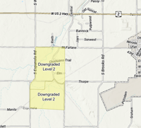
The Espanola Fire has homes in the following area under level 2 evacuation near Medical Lake:
NORTH TO MCFARLANEAND SOUTH TO THORPE. EAST TO RITCHEY AND WEST TO ESPANOLA.
MANILA ON THE SOUTH. THORPE ON THE NORTH. ESPANOLA ON THE WEST. RITCHEY ON THE EAST.