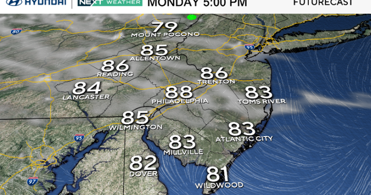
We’re starting the week with fantastic weather here in the Philadelphia area. Monday brings sunshine, low humidity and highs in the upper 80s, with a few spots near 90.
Overnight, expect clear skies, calm winds and lows in the upper 50s to low 60s. A touch of haze from Canadian wildfire smoke is possible, which could filter the sun and slightly limit afternoon warmth. We’ll have a better chance at more effects of the smoke Tuesday and into the first part of Wednesday.

CBS News Philadelphia
Tuesday stays warm and dry, with highs near 90 and a bit more humidity under partly cloudy skies. Clouds will build Tuesday night as moisture moves in on an onshore flow.
By Wednesday, high pressure to our north keeps us mainly dry, but clouds increase from a system to our south. A few stray showers are possible Thursday through Saturday, mainly south and east of the city. Temperatures will dip into the upper 70s and low 80s Thursday before rebounding into the upper 80s next weekend.
Late in the week, we’re watching the potential for a low-pressure system to develop offshore and move north. Its track remains uncertain, so for now we’re keeping only slight rain chances in the forecast.
Be aware: There is a moderate rip current risk down at the Jersey Shore and a high rip current risk at the Delaware beaches. Learn what signs to look out for if you venture into the water this summer.

CBS News Philadelphia
In case you were wondering …
Meteorological summer ends in 28 days on Sept. 1.
Astronomical summer ends and fall begins in 50 days on Sept. 22.
Labor Day is only 29 days away Sept. 1.
Daylight Saving Time ends in 90 days on Nov. 2.
Here’s your 7-day forecast:

CBS News Philadelphia
Monday: Mostly sunny. High 88, Low 62.
Tuesday: Partly cloudy. High 88, Low 65.
Wednesday: Mostly cloudy. High 81, Low 69.
Thursday: A stray shower. High 81, Low 68.
Friday: More clouds. High 83, Low 65.
Saturday: Partly cloudy. High 86, Low 66.
Sunday: Partly cloudy. High 88, Low 69.
More from CBS News