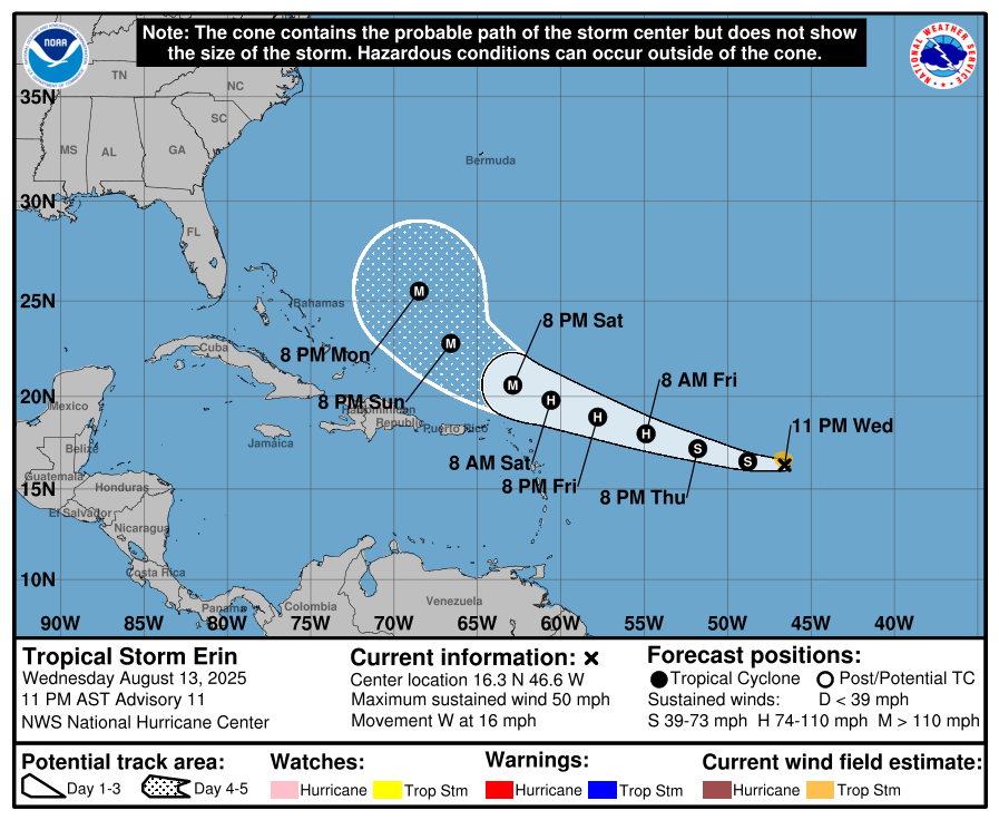
While it is still too early to know the exact path of what is expected to be the season’s first hurricane, the Outer Banks will likely experience rip currents, some ocean overwash and beach erosion next week from Erin.
The fifth tropical cyclone of 2025 formed off the west coast of Africa on Monday, but has been battling dry air and cooler water temperatures over the last 48 hours.
Forecasters at the National Hurricane Center said Wednesday evening that Erin is starting to move into a more favorable environment, and are calling for it to reach hurricane status sometime on Friday.
Erin is expected to reach major status of category 3 or higher over the weekend, with maximum sustained winds forecast to reach 120 mph in the core by Monday.
However, the track of the storm is much less certain beyond the next five days.
“(T)here is a greater than normal uncertainty about what impacts Erin may bring to portions of the Bahamas, the east coast of the United States, and Bermuda,” NHC said in their forecast discussion Wednesday evening.
But the hurricane center said there is increasing confidence that the risk of dangerous surf and rip currents along the Outer Banks and the rest of the coast is increasing.
According to the National Weather Service, about 10% of rip current fatalities have been due to swells from tropical cyclones over the last two decades.
Between 2000 and 2021, there were approximately 143 surf fatalities caused by Atlantic tropical cyclones in the continental U.S., 100 of which were due to rip currents.
Over half of these fatalities occurred when the tropical cyclone had no impacts at the fatality location other than rough surf and marine conditions (i.e., the storm stayed out to sea or made landfall elsewhere in the Atlantic).
On a local level, 10% of rip current fatalities in the Carolinas between 2000 and 2022 have been due to swells from tropical cyclones.
The most prominent example happened in 2019, the same year that Hurricane Dorian devastated Ocracoke Island with historic soundside storm surge, and caused flooding in Buxton and Hatteras as it made landfall at Cape Hatteras on September 6.
Three weeks later, Hurricane Lorenzo became a powerful major hurricane for days and was the northernmost category 5 storm on record in the Atlantic.
From September 26 through 30, Lorenzo was a category 2 hurricane or stronger and was either moving right at the U.S. or moving slowly.
This generated long period swells that traversed the Atlantic, taking four days for the swells to reach the East Coast.
As a result, a deadly rip current outbreak occurred along the U.S. East Coast, despite Hurricane Lorenzo getting no closer than 1,700 nautical miles from the coast. Strong rip currents and hazardous surf conditions were reported up and down the coastline.
Eight lives were lost in total, six of which were rip current related, between September 30th and October 3rd. Four of these fatalities occurred in North Carolina.
Lorenzo led to the most U.S. surf fatalities from an Atlantic tropical cyclone since Hurricane Gabrielle in 1989.
Even if Erin stays offshore, there will likely be powerful swells that at high tide can cause ocean overwash.
Areas with little-to-no dune, especially along the oceanfront of the north end of Ocracoke Island, between Hatteras village and Frisco, Buxton north of Cape Point, in Rodanthe, and on Pea Island, will be the most vulnerable through multiple high tide cycles next week.
There is one factor that may work in our favor with the timing of Erin’s passage in terms of the severity of overwash.
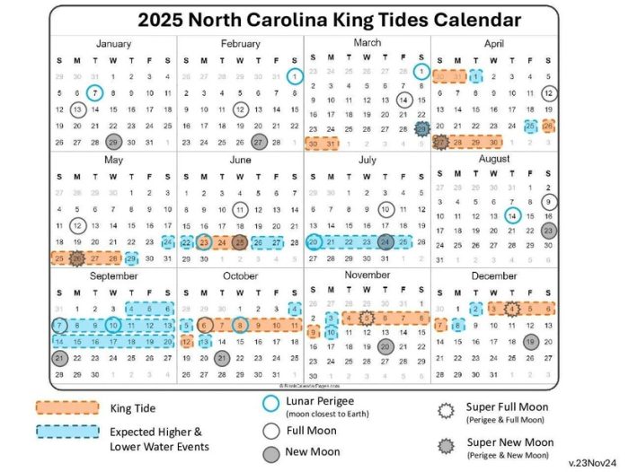
When a hurricane or nor’easter coincides with what is known as a King Tide, major ocean overwash and erosion is an almost certainty.
A King Tide, known scientifically as a perigean spring tide, is when the moon is either new or full and closest to Earth, and when the highest and lowest tidal levels occur.
The moon reaches perigee this Friday, while the next new moon is on August 23.
A period of higher and lower tide levels will take place between September 4 and 20, while the next King Tide will happen between October 6 and 12.
More about King Tides can be found at the N.C. King Tide Project website.
So while there is still a lot unknown about Erin’s eventually path next week, residents and visitors should keep an eye on the latest forecasts from the National Hurricane Center and National Weather Service offices in Newport and Wakefield.
Official updates will also be made by emergency management officials in the counties of Currituck (Carova Beach, Corolla), Dare (Duck to Hatteras village) and Hyde (Ocracoke).
“As we approach the climatological peak of the hurricane season, this is an opportune time to ensure your preparedness plans are in place,” NHC said.
The National Weather Service will hold Hurricane Community Forums in Rodanthe and Wanchese on Thursday.
The first forum begins at 1 p.m. will take place at the Rodanthe-Waves-Salvo Community Building at 23646 North Carolina Highway 12 in Rodanthe.
The second forum is at the Coastal Studies Institute at 6:00 p.m. at 850 NC-345 in Wanchese.