All eyes will be on major Hurricane Erin this week as the storm begins its northerly track toward the eastern seaboard.
While the heart of the storm will likely stay well offshore (fortunately), we will have several impacts in the Philadelphia region, especially along the Jersey Shore and Delaware beaches.
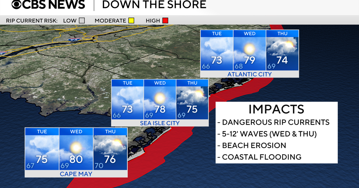
How will Hurricane Erin affect the Philadelphia region?
Here’s how Hurricane Erin could affect the Jersey Shore and Delaware beaches:
- High rip current risk will continue through at least Friday
- Long period swells will generate rough surf and large breaking waves
- Eight to 12-foot seas on Wednesday could build as high as 10-15 feet on Thursday
- Dangerous swimming and boating conditions all week
- Beach erosion and coastal flooding are likely — there’s already a coastal flood advisory for the Jersey Shore and Delaware
In addition, the wind gusts will likely peak on Thursday with gusts as high as 50 mph from the east, adding in the potential for beach erosion and flooding.

CBS News Philadelphia
Away from the coast, impacts from Erin will be limited.
The bigger story will be the cool and cloudy pattern that we’ll be stuck in through at least the first half of the week — highs only in the 70s with limited sun and the chance for spotty showers. A cool breeze will make it feel more like fall than August. We’ll start to brighten up and warm up by the end of the week into the weekend as Erin moves away.
Friday and Saturday are looking a bit warmer with highs in the 80s under sunny skies, with the possibility of more storms next Sunday.
Here’s your 7-day forecast:

CBS News Philadelphia
Tuesday: Mostly cloudy. High 76, Low 66.
Wednesday: Partly sunny? High 80, Low 67.
Thursday: Mostly sunny. High 79, Low 66.
Friday: Mostly sunny. High 84, Low 63.
Saturday: Partly sunny. High 84, Low 64.
Sunday: Stray shower. High 84, Low 69.
Monday: Partly cloudy. High 84, Low 67.
More from CBS News