
NEW YORK – New York and New Jersey are prepping for Hurricane Erin to make downfall on the U.S. coastline, and while the storm isn’t going to make landfall, residents will definitely feel the impact.
Local beaches are already preparing for the worst as the storm still poses many threats to beach-goers in New Jersey, New York and Long Island.
Here’s a look at what the NYC area can expect, a timeline, a tracker and which areas face the biggest threats:
Will Hurricane Erin hit the NYC area?
Local perspective:
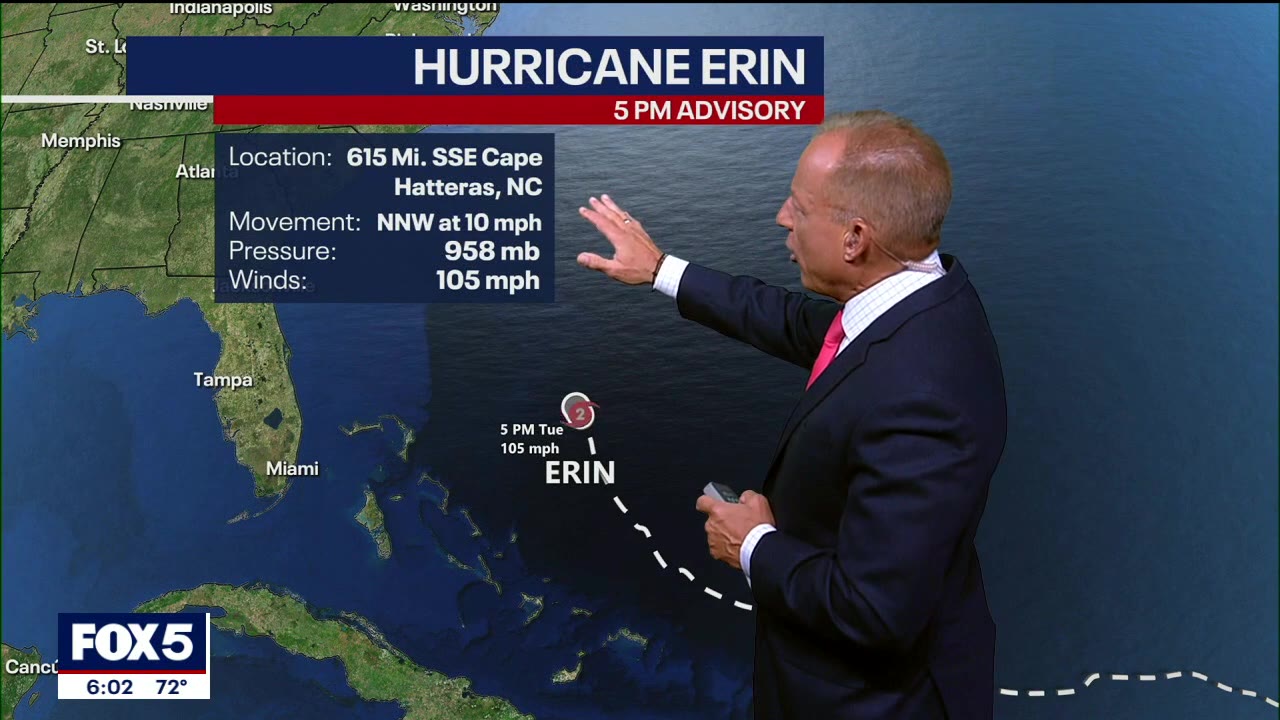
Currently, Erin is a Category 2 storm, but beach-goers should still be wary, as life-threatening surf and dangerous rip currents are forecast to threaten the area all week.
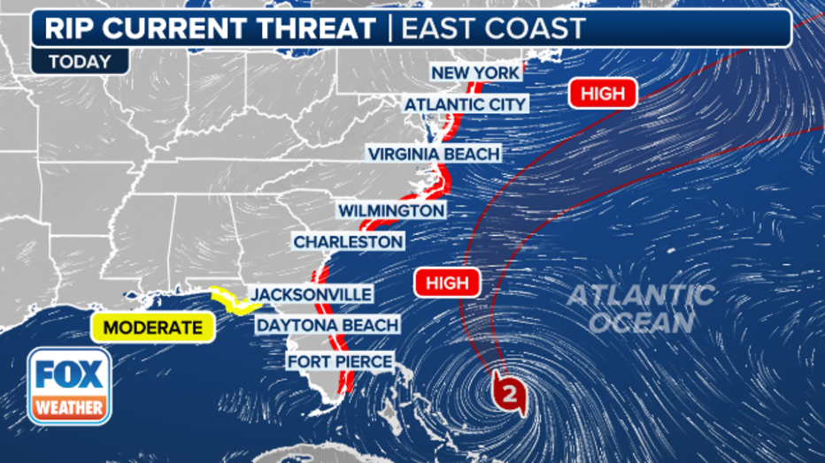
U.S. rip current impacts. (FOX Weather)
What to expect
- Increasing wave heights, as high as 15 to 20 feet
- Dangerous rip currents
- Wind gusts up to 30 mph possible
- Minor coast flooding is also possible
These rip currents pose real dangers to swimmers. Earlier this month, one person died and six were rescued from rip currents in Seaside Heights. In nearby Berkeley Township this weekend, two swimmers were rescued after getting caught in rip currents. Also on Friday, a 13-year-old girl drowned in Belmar, New Jersey, though the cause of death remains under investigation.
Several local beaches, including New York City’s, are closed for swimming due to these dangers. Click here for more on NYC’s precautions and here to track NJ beach closures.
Additionally, NY Gov. Kathy Hochul has directed the Office of Parks, Recreation, and Historic Preservation to suspend swimming at Long Island ocean beaches due to flooding, rough surf conditions and potential rip tides.
High surf advisory
A high surf advisory is in effect from Wednesday through Friday evening for all Atlantic Ocean beaches and will likely need to be extended.
Ocean seas are expected to build to 11 to 15 feet or higher by Thursday into Friday morning, with the highest waves forecast south and east of Moriches Inlet, before subsiding into the weekend.
Dangerous conditions are anticipated around inlets and the entrance to eastern Long Island Sound, along with the potential for gale-force wind gusts from Thursday into early Friday morning, especially south and east of Moriches Inlet, according to the National Weather Service.
Erin tracker: Where is Erin today 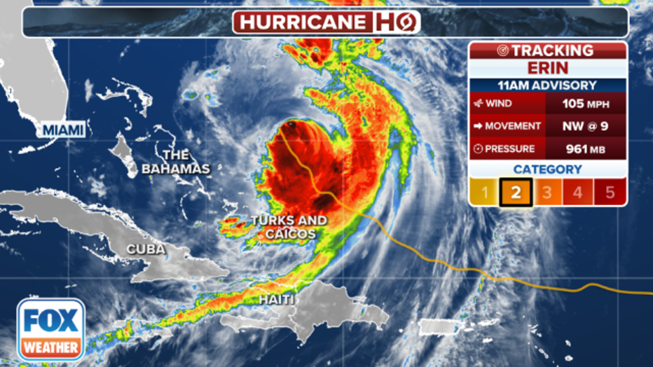
Tracking Hurricane Erin in the Atlantic. (FOX Weather)
As of Tuesday afternoon, the storm was in the Caribbean, headed toward the southeast Bahamas. It is projected to move north later this week.
When the NYC area will feel Erin’s impacts
Timeline:
Here’s a look at what to expect the rest of this week.
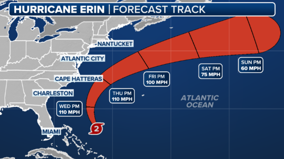
Hurricane Erin’s forecast cone. (FOX Weather)
Tuesday
The National Weather Service issued a high rip current risk statement, which goes into effect Tuesday evening for Long Island and New York City.
Wednesday
Rip current risk statements for New York and New Jersey remain in effect.
Thursday and Friday
Longer term, life-threatening surf and rip currents will reach their peak on Thursday and Friday.
Wave heights will reach their peak and could be as tall as 15 to 20 feet.
Biggest threats from Hurricane Erin
Hurricane Erin is expected to cause extreme damage to the Outer Banks in North Carolina, forcing evacuations. Severe inland flooding is anticipated, with homes and businesses at risk of structural damage, numerous roads likely becoming impassable, and vehicles potentially submerged under several feet of water.
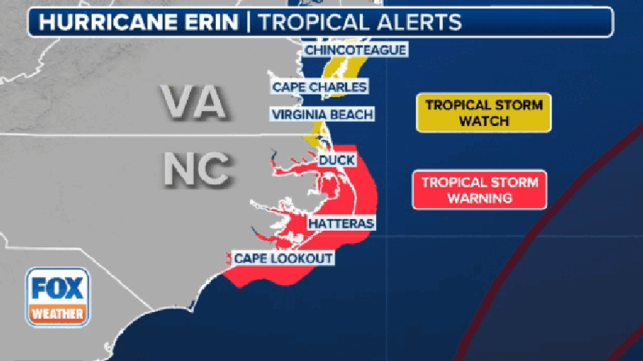
Big picture view:
Erin is forecast to remain a Category 2 or 3 storm as it passes offshore, with winds up to 60 mph and waves reaching 20 feet, exacerbating ongoing beach erosion and rising sea levels in the Outer Banks.
Already, the hurricane pelted the Turks and Caicos Islands and the southeast Bahamas.
More storm threats
What’s next:
The National Hurricane Center (NHC) has identified a tropical system with a medium chance of development in the Atlantic Ocean’s Main Development Region, potentially forming into a tropical depression later in the week.
A large group of disorganized thunderstorms off the coast of Africa is moving westward, encountering favorable conditions for development as it approaches the Caribbean islands, possibly nearing the Leeward Islands by Friday.
The next named storm in the 2025 Atlantic hurricane season would be Fernand.
The Source: This article uses information from FOX 5 NY meteorologists Nick Gregory and Audrey Puente, the National Weather Service, FOX Weather and the Associated Press.