
What to Know
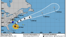
- As of the National Hurricane Center’s latest update, Erin remained a Category 2 hurricane with maximum sustained winds around 100 mph. It was about 400 miles south-southeast of North Carolina’s Cape Hatteras.
- While not expected to impact the tri-state directly, Erin is likely to bring potentially deadly rip currents to New York and New Jersey shores over the next few days. NYC public beaches, along with several on Long Island and in New Jersey, have closed to swimming as a precaution through Thursday.
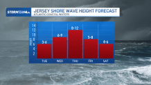
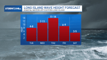
- Erin should remain a Category 2 storm as it makes its closest approach to the tri-state. Waves will peak on Thursday, though we’ll start to see high surf conditions kicking in as early as Wednesday morning. Thursday’s surf could top off at 15 feet for spots along Long Island.
People trying to enjoy the last hurrahs of summer along the coast are being met on Wednesday with rip-current warnings, closed beaches and treacherous waves as Hurricane Erin inches closer, still a powerful storm as it treks northwest after lashing Turks and Caicos and Bermuda.
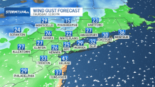
While forecasters remain confident that the center of the monster storm will stay far offshore, the outer edges are expected to bring high winds, large swells and life-threatening rip currents into Friday. The biggest swells along the East Coast could come as early as Wednesday.
New York City closed its beaches to swimming on Wednesday and Thursday, and New York Gov. Kathy Hochul ordered three state beaches on Long Island to prohibit swimming through Thursday. Several New Jersey beaches also will be temporarily off-limits, including those in Wildwood, while some towns in Delaware have restricted ocean access.
Area beaches are already facing a high rip current threat, mainly due to a persistent easterly wind. But we will see high risk for dangerous rip currents through the rest of the week, especially as Erin passes offshore on Thursday.
Erin should remain a Category 2 storm as it makes its closest approach to the tri-state. Waves will peak on Thursday, though we’ll start to see high surf conditions kicking in as early as Wednesday morning.
Wednesday’s waves could reach heights up to 10 feet, while Thursday’s surf could top off at 15 feet for spots along Long Island.
These high surf and dangerous rip currents make for an extremely hazardous situation in the water. Stay out of the ocean this week, even when a lifeguard is on duty. Even the strongest swimmers may have trouble.
In addition to the rip current threat, Erin will prompt coastal flooding and beach erosion. Coastal flood statements were issued Monday for the evening’s high tide, with minor flooding possible in low-lying areas.

But as the week goes on, we’ll see coastal flooding intensify from minor to moderate levels, exacerbated not only by Erin’s nearby influence, which will further ramp up our easterly wind, but also the upcoming new moon on Saturday.
Where is Erin now?
Erin has become an unusually large and deceptively worrisome storm, with its tropical storm winds stretching 230 miles from its core. Forecasters expect it will grow larger as it moves through the Atlantic and curls north.
On Tuesday, it lashed the Turks and Caicos Islands, where government services were suspended and residents were ordered to stay home, along with parts of the Bahamas before its expected turn toward Bermuda.
Tropical storm watches were issued for Virginia and North Carolina as well as Bermuda.
As of the National Hurricane Center’s latest update, Erin remained a Category 2 hurricane with maximum sustained winds around 100 mph. It was about 400 miles south-southeast of North Carolina’s Cape Hatteras.
Tropical storm watches and warnings are in effect.