This Afternoon’s Forecast:
We’re tracking another hot and muggy day with feels-like temperatures in the triple digits and more isolated thunderstorms afternoon into the evening. You can track radar below:
Thunderstorms will still be possible, but more isolated in nature by the time we get past sunset. Below you can see the 9PM futuretrack where storms are hit-or-miss. Any storms that do remain will likely be electric and loud. Futuretrack (Copyright 2025 by KPRC Click2Houston – All rights reserved.)Thursday’s Forecast:
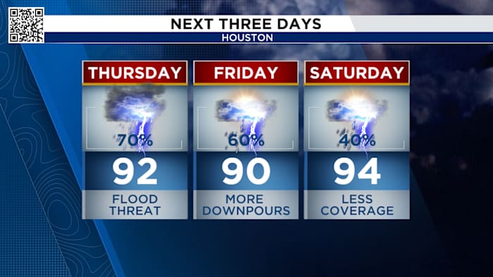
A stalled front drapes into southeast Texas Thursday and this will bring more widespread rain with the potential for street flooding. These storms look to be most widespread during the hottest time of the day.
This will also mean you’ll need to plan on extra time for driving! Storms will be likely for the evening commute and after-school pick-up.
Thursday Afternoon
The flood threat is low (1 on a scale of 4). Any thunderstorm could drop a quick inch or two. This flooding treat includes Friday too.
Marginal threat for all of SE Texas for street flooding (Copyright 2025 by KPRC Click2Houston – All rights reserved.)Tracking Hurricane Erin:
Hurricane Erin continues to bring coastal hazards for the east Coast. There are coastal flood alerts from Florida through Long Island and Tropical Storm Warnings from coastal North Carolina through New Jersey.
Tropical storm alerts from Hurricane Erin (Copyright 2025 by KPRC Click2Houston – All rights reserved.)
Life-threatening rip currents are a major concern along the beaches of the U.S. East Coast and Bermuda throughout the rest of the week.
Erin path this week (Copyright 2025 by KPRC Click2Houston – All rights reserved.)
Tropical storm conditions and coastal flooding are possible in the North Carolina Outer Banks by late Wednesday into Thursday morning. Storm surge areas across the Carolinas could reach between 2-4 feet producing significant flooding well inland from the beaches.
Deadly rip currents will form along the east coast. (Copyright 2025 by KPRC Click2Houston – All rights reserved.)The tropical storm train continues in the Atlantic:
A tropical wave in the eastern tropical Atlantic has a 60% chance of development into a tropical system within the next 7 days. This storm is tracking farther south than Erin. If it can remain disorganized for several more days it has a chance to move into the Caribbean and possibly the Gulf.
Tropical Outlook (Copyright 2025 by KPRC Click2Houston – All rights reserved.)
Make sure your family is prepared for whatever comes our way this hurricane season. You can check out our 2025 Hurricane and Flood Survival Guide here.
Your extended forecast:
Temperatures lower a little Thursday and Friday because of the expected widespread rain and clouds. There is also a chance of a drier weather pattern next week.
10 Day Forecast
If you notice interesting weather in your neighborhood, share your photos and videos with KPRC 2 at Click2Pins!
Anthony’s Weather Lab
More Stories Like This In Our Email Newsletter
Copyright 2025 by KPRC Click2Houston – All rights reserved.