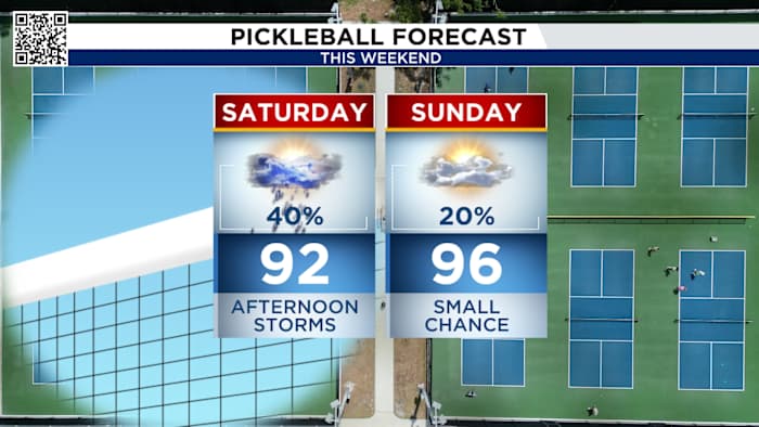
Showers and thunderstorms have been impacting SE Texas every single day, and that will not end this weekend! Saturday will bring a 40% chance for showers and storms.
LIVE RADAR: Heavy downpours prepare to soak Houston area as weekend kicks off
A stubborn boundary stretched along I-10 is once again expected to spark strong thunderstorms, making for another active weather day.
This Evening’s Forecast:
As we head into the evening, shower and storm chances will start to wind down. Roads will still be wet in many areas. Thanks to the cloud cover and rain cooled air, it may be a really comfortable night ahead.
Check out the radar below:
Flood risk across most of Southeast Texas
With repeated rounds of slow-moving storms, much of Southeast Texas is under a heightened flood risk. The KPRC 2 Weather Team points to the same boundary that’s been fueling storms as the trigger for the increased flooding threat. The flood risk area covers almost all of Southeast Texas, as Saturday will also see a chance for heavy rain
Rainfall totals through the weekend (Copyright 2025 by KPRC Click2Houston – All rights reserved.)
While significant flooding wasn’t reported with these recent storms, conditions remain favorable for flooding due to the slow nature of these thunderstorms.
Weekend Forecast:
On Saturday, rain chances are 60% with temperatures in the mid-90s and another round of downpours likely as the boundary continues to stall across the coastline. Sunday and Monday looks quieter with just a 20% chance of an afternoon sea breeze storm.
Weekend ForecastTRACKING THE TROPICS: Hurricane Erin:
Erin is quickly moving away from the United States but rough seas and dangerous rip current will affect the east coast Friday.
Hurricane Erin path (Copyright 2025 by KPRC Click2Houston – All rights reserved.)A lot to watch in the Atlantic but nothing impactful just yet:
There is a 70 percent chance the red system below will strengthen into Tropical Storm Fernand in the next two days, it will follow a similar path as Erin but farther to the east.
Tropical Outlook (Copyright 2025 by KPRC Click2Houston – All rights reserved.)
Another tropical wave southeast of this has a 40% chance of development and could head on a more westerly path toward the Windward Islands by next Tuesday. Not much to say about the yellow disturbance.
Make sure your family is prepared for whatever comes our way this hurricane season. You can check out our 2025 Hurricane and Flood Survival Guide here.
Your extended forecast:
Temperatures will be lower on Friday because of the frontal boundary, rain and clouds. Sunday and Monday will be quieter with an isolate sea breeze storm possible. We return to an active weather pattern Tuesday.
10 Day Forecast
If you notice interesting weather in your neighborhood, share your photos and videos with KPRC 2 at Click2Pins!
Anthony’s Weather Lab
More Stories Like This In Our Email Newsletter
Copyright 2025 by KPRC Click2Houston – All rights reserved.