High pressure remains in control into Tuesday in the Philadelphia region, keeping skies mostly clear and conditions cool.
Overnight lows dip into the 40s and 50s, with some sheltered spots possibly near 40 degrees, though not cold enough for frost.
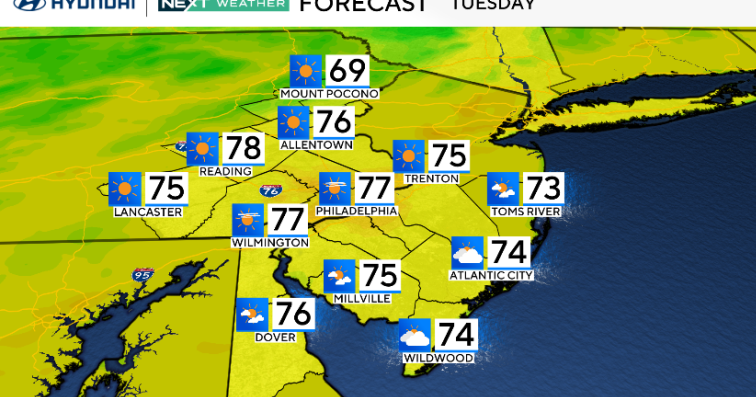
Tuesday stays pleasant with highs in the low to mid 70s, a light northeast breeze and increasing clouds along the coast by afternoon.

CBS News Philadelphia
By Tuesday night and Wednesday, a coastal low develops offshore and lifts north. This system should stay east of us, but it may throw a few scattered showers our way, mainly closer to the Jersey Shore and Delaware beaches, with the slight chance of a thunderstorm.
Winds turn breezier out of the northeast, especially near the coast, with gusts up to 25–30 mph. Highs on Wednesday hold in the upper 60s to low 70s, keeping the cool feel going.
Conditions improve again on Thursday into the weekend as the low departs. Skies turn sunnier and temperatures rebound into the mid and upper 70s by Thursday afternoon.
A weak cold front slides through late Thursday, but it looks dry.
From Friday into the weekend, high pressure builds back in, bringing a stretch of dry, seasonable weather with comfortable highs in the 70s and low humidity.
Here’s your 7-day forecast:

Tuesday: Sunny. High 77, Low 55.
Wednesday: Coastal shower. High 73, Low 61.
Thursday: Warmer, sunny. High 82, Low 59.
Friday: Sunny. High 81, Low 60.
Saturday: Sunny. High 79, Low 58.
Sunday: Mostly sunny. High 81, Low 57.
Monday: Increasing clouds. High 82, Low 60.
More from CBS News