FORECAST HIGHLIGHTS
-
SLIGHTLY MORE HUMIDITY: Humidity becoming more noticeable
-
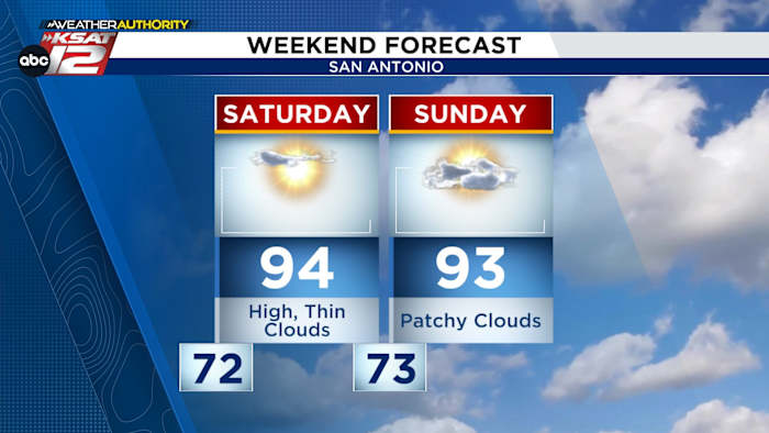
QUIET WEEKEND: No changes, stays hot
-
NEW THREAT IN ATLANTIC: Watching for development
FORECAST
Happy Friday, y’all! We are stuck in our current weather pattern. While this is a bit odd for September, it’ll keep the forecast very consistent.
MORE HUMID
One small, but noticeable change is the humidity. Dewpoints are up and so too are the morning temperatures. It still feels nice, but the 60s we saw earlier this week show no signs of returning.
More of the same as we move into the weekend (Copyright 2025 by KSAT – All rights reserved.)
WATCHING THE ATLANTIC & PACIFIC
Tropical Storm Mario is positioned off the coast of Mexico, and there are also areas of possible development in the Atlantic. What does that mean for San Antonio? There’s potential for some of Mario’s moisture to make its way north, but for now, forecasts show little impact locally, with minimal rainfall expected in the week ahead.
Tropical Storm Mario has formed off the Coast of Mexico (Copyright 2025 by KSAT – All rights reserved.)
A wave with promise has moved off the African coast. The National Hurricane Center has given this system a 40% chance of development. It’s still very early, so we have plenty of time to watch how this wave evolves.
MOVING FORWARD
Don’t look for rain anytime soon. An area of high pressure remains dominant, keeping meaningful rain chances out of the picture.
7 Day Forecast (Copyright 2025 by KSAT – All rights reserved.)Daily Forecast
KSAT meteorologists keep you on top of the ever-changing South Texas weather.
QUICK WEATHER LINKS
Copyright 2025 by KSAT – All rights reserved.