![]()
Nor’easters: How they form and why they trigger weather emergencies
Nor’easters are major storms that often push up the East Coast of the U.S. and bring major disruptions to the Northeast with snow, flooding and more.
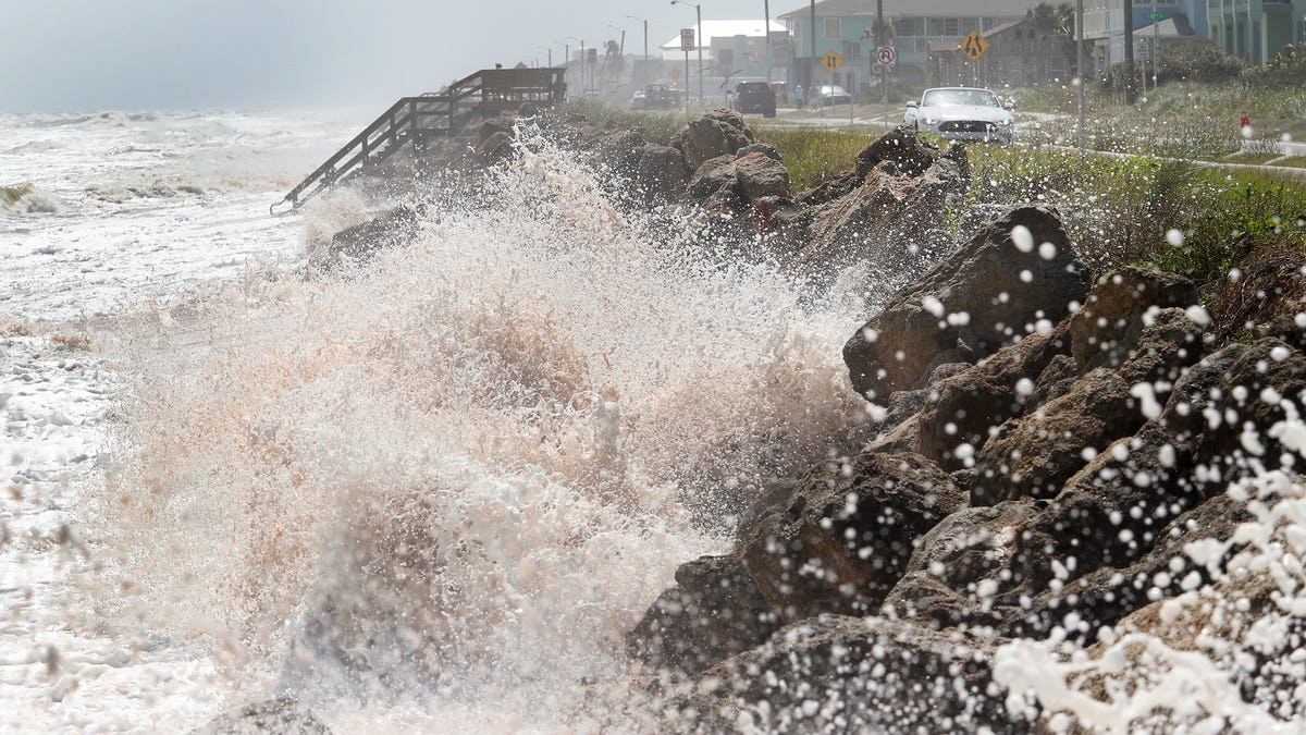
A coastal storm that could become the season’s first Nor’easter is moving up the East Coast this weekend, potentially affecting areas from Florida to Massachusetts.
Forecasters say its strength and exact path will determine how severe the impacts are in New York. Coastal communities from the Carolinas to the Mid-Atlantic could face higher tides, strong northeast winds and beach erosion — especially if the storm tracks closer to the shore.
“The main concern continues to be with the potential of a strong coastal low Sunday into early next week,” according to the National Weather Service office in New York. “There is still a large amount of uncertainty with impacts which are dependent on the exact track and intensity of a deepening low pressure Saturday night into Sunday near the Carolinas/Southern Middle Atlantic coast. How far north the low tracks along with its strength later Sunday and Monday will be the main determining factors for potential wind and coastal flood impacts.”
What is a Nor’easter?
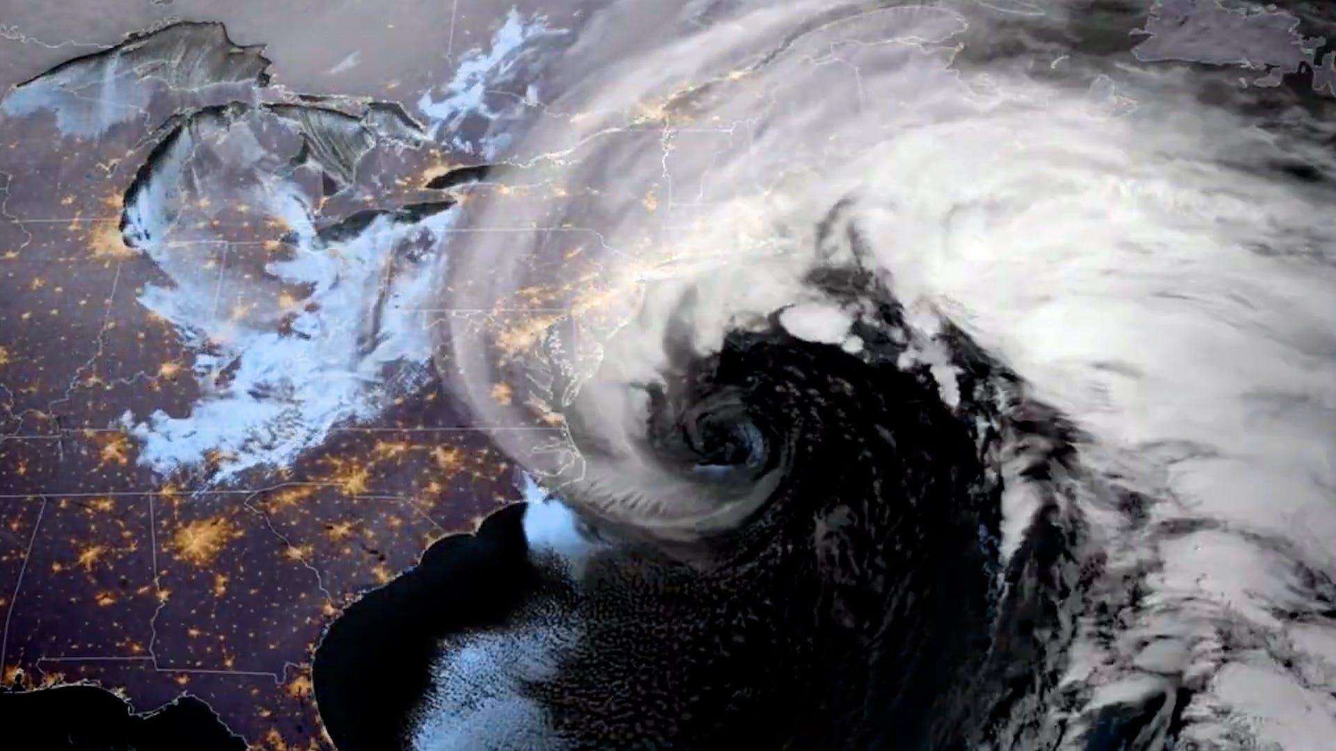
A Nor’easter is a storm along the East Coast of North America that typically blow over coastal areas. These storms can occur at any time of year but are most frequent and most intense between September and April, according to the National Weather Service.
Nor’easters usually develop between Georgia and New Jersey, within about 100 miles of the coast, and generally move northeastward, reaching maximum intensity near New England and the Canadian Maritime Provinces. They often bring heavy precipitation — rain or snow — along with gale-force winds, rough seas and sometimes coastal flooding.
Potential impacts of the Nor’easter in New York
- Heavy rain: Long-duration rainfall of 1–2 inches possible Sunday into Monday; could reduce visibility but widespread freshwater flooding is not expected due to dry pre-existing conditions.
- Strong winds: Gusts over 40 mph possible along the Connecticut coast, with peak gusts near 60 mph along exposed shorelines; Long Island could see a 50% chance of gusts exceeding 40 mph.
- Coastal flooding and beach erosion: Minor to moderate flooding and erosion possible along Long Island, the Connecticut coast, and other exposed shorelines.
- Marine hazards: Gale-force conditions likely along coastal waters, making boating and marine travel dangerous.
- Reduced visibility and travel hazards: Heavy rain combined with strong winds could create hazardous conditions for driving and coastal travel.
How do Nor’easters develop?
The U.S. East Coast provides an ideal environment for Nor’easters. In winter, the polar jet stream pushes cold Arctic air south across Canada and the U.S., then east toward the Atlantic Ocean, according to the National Weather Service. At the same time, warm air from the Gulf of Mexico and the Atlantic moves northward. The contrast between the cold land air and relatively warm coastal waters — kept mild by the Gulf Stream — fuels these storms, creating the strong winds and precipitation that define a Nor’easter.
Do Nor’easters always have snow?
No. Whether a Nor’easter brings snow, rain, or a mix depends on the storm’s track and temperatures:
- Snow: Most common in the northern Mid-Atlantic and New England when Arctic air dominates.
- Rain: More likely in the Southeast and southern Mid-Atlantic, where temperatures are warmer.
- Mixed precipitation: Possible in areas near the transition zone, with sleet or freezing rain.
Even without snow, Nor’easters can still produce strong winds, heavy rain, rough seas and coastal flooding, making them dangerous storms regardless of the type of precipitation.
Why is it called Nor’easter?
It’s called a Nor’easter because of the direction of the prevailing winds during the storm. In these systems, the winds along the coast usually blow from the northeast.
How do Nor’easters differ from tropical storms or hurricanes?
Nor’easters are typically associated with colder seasons and form from a temperature contrast between cold Arctic air and relatively warm Atlantic waters.
Tropical storms and hurricanes form over warm tropical or subtropical waters, and predominantly develop in warmer months.
Nor’easters also have a larger wind field, while tropical storms have a well-defined eye with the strongest winds near the center.
New York weather watches and warningsStay informed. Get weather alerts via text
Brandi D. Addison covers weather across the United States as the Weather Connect Reporter for the USA TODAY Network. She can be reached at baddison@gannett.com. Find her on Facebook here.