Skies will be mostly clear across the Philadelphia region, with more clouds lingering farther south.
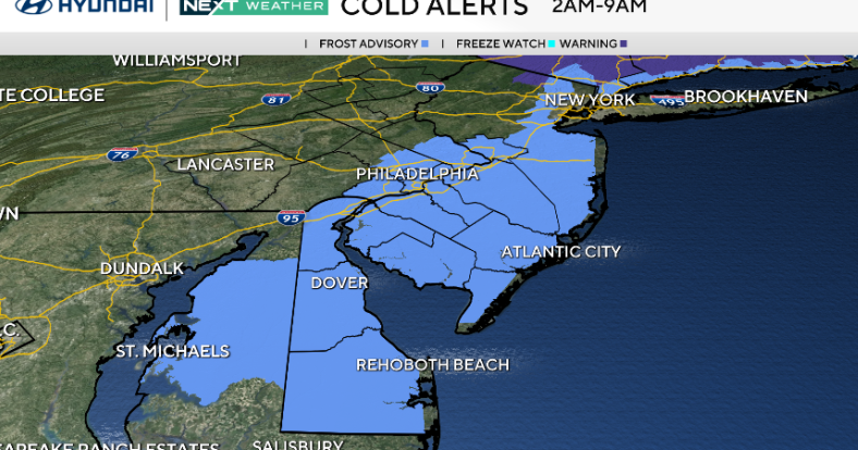
Temperatures will fall into the upper 20s and low 30s north and west, and upper 30s to low 40s south and east. With light winds and clear skies in many spots, patchy frost is likely again overnight. A frost advisory remains in effect for much of the area through early Monday morning.
Monday stays dry and seasonable with highs in the upper 50s to low 60s and light northeast winds.

CBS News Philadelphia
By Monday night and Tuesday, a coastal low will form off the Carolinas and move out to sea, bringing a chance of light drizzle or spotty showers along the coast. Winds will pick up near the shore, gusting up to 30 or 35 mph.
The next major system arrives mid to late week as a strong low moves from the Tennessee Valley toward the Great Lakes, possibly spawning a secondary low near our region Thursday. This setup could bring rain, gusty winds and another round of coastal flooding before drier weather returns Friday into the weekend.
Meanwhile, Hurricane Melissa has intensified into a powerful Category 4 storm with winds near 145 mph. The storm is moving slowly west, just south of Jamaica, and is expected to make landfall there Tuesday as a major hurricane.
Catastrophic flash flooding, landslides and a storm surge up to 13 feet are likely along Jamaica’s southern coast. Heavy rain will also spread into southern Hispaniola and eastern Cuba, where flooding and destructive surf are expected through midweek.

CBS News Philadelphia
Here’s your 7-day forecast:
Monday: Mostly sunny. High 60, Low 41.
Tuesday: Late showers. High 59, Low 43.
Wednesday: Shower or two. High 58, Low of 46.
Thursday: Rain likely. High 64, Low 52.
Friday: Departing showers. High 61, Low 50.
Saturday: Seasonable November start. High 61, Low 46.
Sunday: Partly cloudy. High 62, Low 42.