SAN ANTONIO – It’s a crisp, cool start to the day across the region.
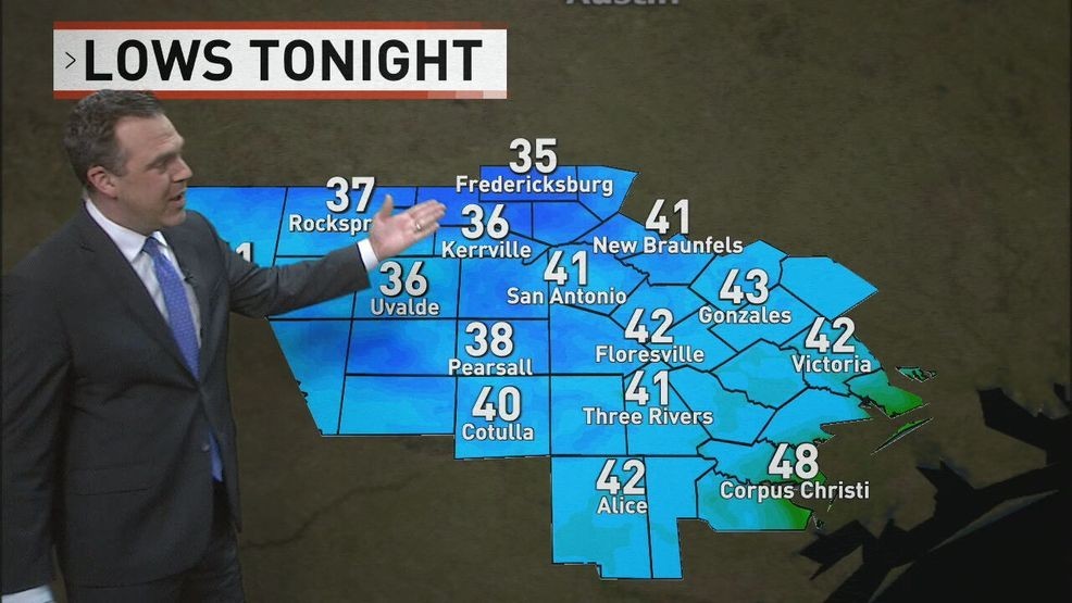
Temperatures are much cooler, starting in the 50s across San Antonio and dipping into the 40s in parts of the Hill Country. It’s a crisp start that makes a sweater or light jacket a must if you’re heading outdoors. Highs today are expected to reach the upper 60s to around 70 degrees, a noticeable change from the summer warmth.
Adding to the fall feel, strong gusty winds will continue throughout the day, reaching up to 40 mph at times. This is creating a high fire danger, and a red flag warning is in effect. Sparks can easily start a fire, and with the dry, windy conditions, it could spread quickly.
Meanwhile, Hurricane Melissa has passed over Jamaica and made landfall in Cuba. The storm is weakening but still remains a major hurricane as it moves northeast, eventually returning to the open Atlantic.
Looking ahead, highs will rebound into the 70s tomorrow, with Halloween afternoon temperatures near 76 degrees. Trick-or-treaters can expect cool, comfortable weather in the mid-60s.
A brief 30% chance of rain arrives Saturday with a passing system, but it moves out quickly. Overall, the week will feature crisp, cool mornings in the 40s and 50s, with sunny, mild afternoons — classic fall conditions for the four zones.
CLICK HERE to send us your weather photos or video.