A cyclone watch has been extended to include Darwin as Tropical Cyclone Fina is forecast to begin tracking back south-west by Thursday evening.
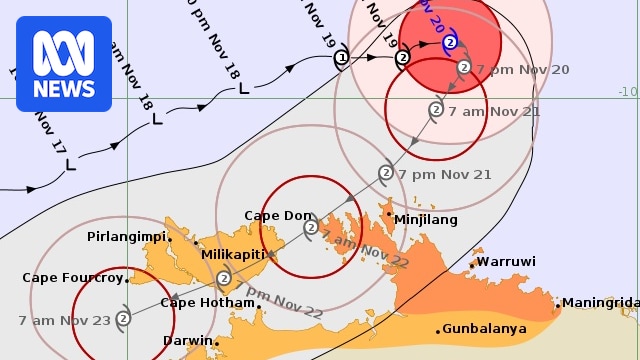
The slow-moving category two system is still expected to make landfall on the Cobourg Peninsula on Saturday morning before moving over Melville Island and past the Northern Territory capital later that day.
A cyclone warning zone remains in place for the area between Cape Don and Maningrida, including Minjilang and Warruwi, with the cyclone watch zone now extended to include Darwin as well as the Tiwi Islands and Gunbalanya.

Amara Gibson climbs on an uprooted tree brought down when Cyclone Marcus struck Darwin in 2018. (ABC News: Jano Gibson)
Bureau of Meteorology (BOM) forecasters say Cyclone Fina is still expected to remain at category two as it moves south-west, but an increase to category three on Friday or Saturday as it nears land is now a “moderate” possibility.
Destructive wind gusts of up to 155km/h are expected to develop between Cape Don and Warruwi from Friday as the system nears the coast, extending to the Tiwi Islands early Saturday and possibly to Darwin later in the day.
Heavy rain and flash flooding are also a possibility along the coast between the Tiwi Islands and Maningrida from Friday, extending to the mainland across the western Top End, including Darwin, on Saturday.
“Coastal residents on the Tiwi Islands, and between Cape Hotham and Maningrida, are specifically warned of a dangerous storm tide as the cyclone centre crosses the coast during Friday and Saturday,” the BOM said on its website.
Are you ready for cyclone season?
“Tides are likely to rise significantly above the normal high tide, with damaging waves and dangerous flooding.”
The BOM is advising residents in the warning zone to “immediately commence or continue preparations, especially securing boats and property, using available daylight hours”.
It says those in the watch zone “should consider what action they will need to take if the cyclone threat increases”.