The Bureau of Meteorology is warning Darwin residents are in for a “long night” with weather conditions set to deteriorate “quickly” and “significantly” this evening due to Severe Tropical Cyclone Fina.
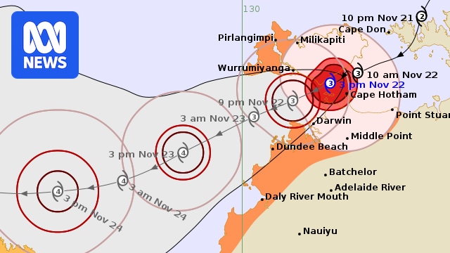
In its advice on Saturday, the Bureau of Meteorology (BOM) said the weather system had reached category three strength in the Van Diemen Gulf, after crossing the Cobourg Peninsula overnight.
The system is continuing to move south-west over the gulf and is expected to pass north of Darwin this evening.
Follow along with our Tropical Cyclone Fina live blog coverage here.
NT Police Acting Assistant Commissioner James O’Brien said for people in Darwin, the worst of the weather is still ahead.
“We will expect to see some damaging winds from about 6pm to about 12 midnight tonight,” he told ABC Radio Darwin.
“It will get worse a bit later on.”
He said about 500 people were in shelters across the Top End.
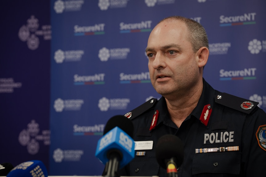
Acting Assistant Police Commissioner James O’Brien’s own power went out mid-way through an interview with ABC Radio Darwin. (ABC News: Michael Franchi)
The weather bureau said Darwin was expected to experience a “rapid increase in winds” later this afternoon and evening.
In a video update posted on the BOM Facebook page, BOM NT hazard preparedness and response manager Shenagh Gamble said Cyclone Fina was a “small and intense” system that would bring wild weather to Darwin and surrounds this afternoon and into this evening.
“Whilst conditions have been deteriorating around Darwin, surrounding communities and the Tiwi Islands during this afternoon, we will see conditions worsen further, and it will be worsening quickly,” she said.
“So as we approach this evening and the sun goes down, conditions are going to deteriorate significantly.”
“It will be a big system and a long night.”
She said conditions would ease considerably from tomorrow morning.
Ms Gamble said the most intense wind conditions would be restricted to coastal communities in and around Darwin, including the Darwin suburbs of Casuarina, Nightcliff and Fannie Bay, as well as the Tiwi Islands community of Wurrumiyanga.
However, she said despite the cyclone approaching the coast around high tide, at sunset, there was no significant storm surge forecast for Darwin.
“However damaging waves and dangerous surf, combined with the high tide and heavy rainfall, will make localised and flash flooding more likely, particularly around creeks and coastal areas,” she said.
In a livestreamed update from the Emergency Operations Centre in Berrimah on Saturday, NT Police Force incident controller Kirsten Engels urged people to shelter indoors as the powerful system drew closer.
Loading…
“Severe Tropical Cyclone Fina is here,” Superintendent Engels said.
“We’ve had days to get ready for this, and there’s no need to panic.
“We are prepared, but the situation is serious.
“We’re seeing the winds and rain pick up in Darwin and the Tiwi Islands already.”
Superintendent Engels said people in affected areas should be activating their household emergency plans, and, if needed, moving to local public shelters.
“We strongly recommend you move to your shelter without delay, if you are not already there,” she said.
She urged people to stay indoors until emergency services said it was safe to resume normal activities, and to keep up-to-date with emergency information via the Secure NT website, Bureau of Meteorology and local radio stations.
“The message is clear. Don’t panic. In actual plans, we’ve got this,” she said.
“We are prepared, and we’re ready, and we’re in this together.”
Loading…
According to the latest BOM advice, Cyclone Fina is currently 60 kilometres north north-east of Darwin and 55 kilometres east south-east of Wurrumiyanga, and is moving west south-west at 9 km/h.
It is bringing sustained winds near the centre of 140 km/h and wind gusts to 195 km/h.
A cyclone warning is in place from the Tiwi Islands and Cape Don to Wadeye, including Darwin, the Cobourg Peninsula, Pirlangimpi, Milikapiti and Wurrumiyanga and Wadeye.
A cyclone watch is in place from Wadeye to Troughton Island in Western Australia, including Kalumburu.
Cyclone Fina was previously at category two intensity for days — having only briefly weakened to a category one system yesterday before regaining category two strength — but the BOM has warned of a chance of it reaching category three.
The change means the system is now classed as a severe tropical cyclone.
The BOM describes a category three cyclone as having “very destructive winds”, with a maximum mean wind speed of 118 to 159 km/h and typical strongest gusts of 165 to 224 km/h.
Power failures are likely, with the system also capable of causing significant damage to crops and trees, some damage to roofs and structures and destruction of some caravans.
BOM is updating its advice every hour, with the next update expected at 1:30pm ACST.