Slick travel, several inches of snow in Vermont and New York on Tuesday due to coastal storm
Most of Vermont expecting 4 to 8 inches, slightly less in the Champlain Valley
WEATHER WARNING. ALL RIGHT. METEOROLOGIST MATT DILORETO HERE AT 2:00. TOP OF THE HOUR ON THIS SNOWY TUESDAY. AND IT IS A COLD ONE. THAT’S WHY THE SNOW IS LIGHTER AND FLUFFIER. AND CONSISTENCY TEMPERATURES IN THE 20S. LET’S TAKE A LOOK AROUND THE REGION AND SHOW YOU WHAT’S GOING ON OUT THERE. RIGHT NOW. WE’VE GOT SEVERAL CAMERAS LINED UP, SOME OF THEM IN NEW YORK, SOME OF THEM DOWN INTO SOUTHERN VERMONT. AND THE SNOW IS COMING DOWN REAL HARD IN BRATTLEBORO. YOU CAN SEE THE BIG FLAKES FLYING THERE. BURY. THE SNOW IS ALSO COMING DOWN. YOU CAN REALLY SEE THOSE FLAKES AND BRATTLEBORO, MAN, IT’S IN THE JACKPOT ZONE FOR SURE. TEMPERATURE DOWN THERE 28. THEY’VE SEEN ABOUT FOUR INCHES OR SO OF SNOW. WITH SEVERAL MORE HOURS TO GO. VISIBILITIES DOWN TO A HALF A MILE WITH THAT MODERATE TO HEAVY SNOW FALLING. WE’VE ACTUALLY GOT LINDSEY JONES LIVE THERE IN BRATTLEBORO RIGHT NOW TO KIND OF SHOW US WHAT’S GOING ON. LINDSEY, HOW HAVE THINGS BEEN GOING ALL MORNING? HI, MATT. WELL, YOU CAN SEE THE SNOW HAS REALLY BEGAN TO PICK UP WHEN I ARRIVED HERE AROUND 10 A.M. IT WAS PRETTY LIGHT. IT WASN’T REALLY STICKING TO THE ROAD, BUT AS YOU CAN SEE, THE SIDEWALKS ARE COVERED AND IT REALLY HAS BEGUN TO PICK UP. PEOPLE AROUND THE AREA WHO’VE BEEN OUT AND ABOUT HAVE TOLD ME THAT THE ROADS HAVE BEGUN TO GET PRETTY SLIPPERY, ESPECIALLY THE BACK ROADS WHERE THE PLOWS HAVEN’T REALLY GOTTEN TO YET. THERE HAS BEEN BUSINESS OWNERS OUT HERE SHOVELING THE SIDEWALKS. WE’VE ALSO STARTED TO SEE PEOPLE FROM THE TOWN CLEAR THE SIDEWALKS AS WELL, AND YOU KNOW, THERE’S STILL LOTS OF CARS GOING. PEOPLE WALKING IN THE DOWNTOWN AREA. BUT, YOU KNOW, IT IS PRETTY QUIET IN BRATTLEBORO AS THIS WEATHER IS HERE. PEOPLE ARE TELLING ME THAT THEY’RE EXPECTING THIS. THEY’RE PREPARED. IT’S WINTER IN VERMONT. HOWEVER, THEY ARE HOPING THAT THE SNOW DOES STOP PICKING UP AND THAT IT DOES NOT CONTINUE LIKE THIS FOR THE REST. FOR THE REST OF THE AFTERNOON. SENDING IT BACK TO YOU, MATT. YEAH, THANKS FOR THAT, LINDSEY. UNFORTUNATELY, IT DOES SEEM LIKE THE SNOW WILL CONTINUE IN THAT AREA, VERMONT, THROUGH THE EVENING COMMUTE AND WITH TEMPERATURES LIKE THIS, IT’S GOING TO CONTINUE STICKING TO THE ROADS EVEN IF THEY’RE TREATED. YOU GOT THE HEAVY SNOW TO KIND OF OVERCOME THAT TREATMENT SOMETIMES. LET’S TAKE A LOOK AT STOWE 25 THERE. AND YOU CAN REALLY SEE THE SNOW COMING DOWN. AND TRAFFIC IS FLOWING PRETTY SMOOTHLY IN NORTHERN AREAS BECAUSE THE SNOW HAS BEEN A LOT LIGHTER, ESPECIALLY UP IN PARTS OF NORTHERN NEW YORK. THERE ARE SOME SLOWER ROADS THERE. BY THE TRI-LAKES YOU GO BETWEEN SARANAC LAKE AND PLATTSBURGH ON ROUTE THREE, THERE’S SOME SLOW TRAVEL. SAME THING WITH ROUTE 73 NEAR KEENE, BUT YOU CAN SEE A LOT OF GREEN ON THE ADIRONDACK NORTHWAY I-87. SO IT SEEMS LIKE THE PLOWS HAVE BEEN OUT AND ABOUT. PLUS, AGAIN, THE SNOW RATES ARE A LITTLE BIT LIGHTER OUT IN NEW YORK NOW, 89 HAS BEEN KIND OF A MESS. YOU CAN SEE FROM BURLINGTON TO MONTPELIER A LOT OF SLOW TRAVEL GOING ON ON THE INTERSTATES. SAME THING WITH THE BACK ROADS, ESPECIALLY THOSE THAT HAVE NOT BEEN PLOWED YET. NORTHEAST KINGDOM INTO GRAFTON COUNTY, NEW HAMPSHIRE HAS ALSO BEEN REAL SLOW GOING, ESPECIALLY I-90 THROUGH THROUGH THREE THROUGH THE NOTCHES. LINCOLN, NEW HAMPSHIRE, UP TO LITTLETON AND THEN IN THE SAINT JOHNSBURY AREA. SLOW TRAVEL ON INTERSTATE 91. NOW WE’VE ALSO GOT A CLOSURE ON ROUTE 103 DOWN IN CENTRAL AND SOUTHERN VERMONT, AND THAT’S BECAUSE OF AN EARLIER CRASH THERE. WITH THE SNOWY CONDITIONS. WE’VE GOT THE HEAVIER SNOW CLEARLY ON STORMTRACKER DOWN THAT WAY WHERE THE JACKPOT ZONE IS. BUT YOU CAN SEE THINGS ARE REALLY LIGHTING UP OVER NORTHERN NEW YORK, PLATTSBURGH, OUT TO SARANAC LAKE. THE SNOW IS JUST NOT COMING DOWN NEARLY AS HARD, WHICH WAS EXPECTED. WE STILL HAVE A COUPLE MORE HOURS OF VERY LIGHT SNOW FOR THESE LOCATIONS, BUT THE WORST OF IT IS LIKELY DONE. AND MOVING OFF TO THE SOUTH AND EAST. BUT YOU CAN SEE A PRETTY HEAVY BAND SETTING UP FROM HINESBURG TO BRISTOL OUT TOWARD MORIAH, TICONDEROGA AND LAKE. THESE DARKER BLUES INDICATING THE HEAVIER SNOW FALLING. AND THIS BAND IS KIND OF STATIONARY. IT’S SITTING IN THE SAME SPOT, SO WE COULD PICK UP ANOTHER FEW INCHES IN THOSE LOCATIONS. IT’S LIGHTER SNOW IN THE NORTHEAST KINGDOM, BUT IT’S STEADY FOR NOW, AND THERE’S A FEW MORE HOURS AT LEAST OF SNOW TO GO IN PLACES LIKE SAINT JAY UP TO NEWPORT. LOOK AT THE DARK BLUES THOUGH. NEAR ALBANY AND SARATOGA SPRINGS. THIS IS WHY SOUTHERN VERMONT WAS ALWAYS EXPECTED TO BE THE JACKPOT ZONE, BECAUSE THIS STILL HAS TO MOVE THROUGH. SO FROM RUTLAND TO LEBANON DOWN TO MANCHESTER AND BRATTLEBORO, WE STILL HAVE ALL OF THIS HEAVY SNOW LEFT TO GO, AND THAT WILL KIND OF COINCIDE WITH PART OF THE EVENING COMMUTE. SO UNFORTUNATELY, IF YOU’RE DRIVING ALONG, I-91 OR EVEN PARTS OF I-89 N
NBC5 First Warning Meteorologist
The NBC5 First Warning Weather Team is tracking alert weather on Tuesday as a winter storm system brings the potential for widespread snow and slick travel conditions.The National Weather Service has issued a winter storm warning for portions of southern and central Vermont, with a winter weather advisory in the Champlain Valley.While snow totals will be lighter in northern areas, temperatures will still be well below freezing. Slick roads should be expected even in areas with light accumulation.Snow timingSnow becomes much lighter and more spotty during the evening commute, though slick travel lingers. Snow will continue steadily in southern Vermont and New Hampshire through the evening commute. Temps hold steady in the 20s.Central and southern Vermont can expect the most snow, with a widespread 4 to 8 inches. Locally higher amounts of 8-12″ are likely, especially south of Route 4 and into New Hampshire. The Champlain Valley can expect 2 to 4 inches by Tuesday night. Many schools are closed or experiencing delays on Tuesday due to the snow. You can see the full list of closures below:Some southern areas could also see power outages from the storm. You can find resources from your utility company here:See the latest snow accumulation forecast:Northern New York and the Champlain ValleyNorthern VermontSouthern VermontView the extended forecast: STAY WEATHER-AWAREFor the latest weather coverage for your area, click here. Stay updated with alerts in the myNBC5 app, which you can download here.For the best weather information and Vermont and northern New York’s Certified Most Accurate forecast, watch NBC5 News by streaming at this link.Don’t forget to follow NBC5 News on Facebook, X (formerly Twitter), and Instagram.Follow the NBC5 First Warning Weather team on social media:Chief Meteorologist Tyler Jankoski Facebook | X | InstagramMeteorologist Ben Frechette Facebook | X | InstagramMeteorologist Matt DiLoreto Facebook | XMeteorologist Andrew Grautski Facebook | XMeteorologist Marissa Vigevani Facebook | X
SOUTH BURLINGTON, Vt. —
The NBC5 First Warning Weather Team is tracking alert weather on Tuesday as a winter storm system brings the potential for widespread snow and slick travel conditions.
The National Weather Service has issued a winter storm warning for portions of southern and central Vermont, with a winter weather advisory in the Champlain Valley.
While snow totals will be lighter in northern areas, temperatures will still be well below freezing. Slick roads should be expected even in areas with light accumulation.
Snow timing
Snow becomes much lighter and more spotty during the evening commute, though slick travel lingers. Snow will continue steadily in southern Vermont and New Hampshire through the evening commute. Temps hold steady in the 20s.
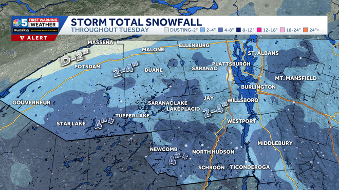
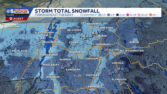
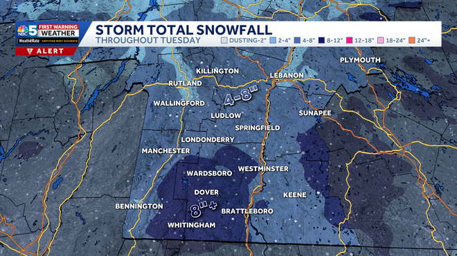
Central and southern Vermont can expect the most snow, with a widespread 4 to 8 inches. Locally higher amounts of 8-12″ are likely, especially south of Route 4 and into New Hampshire. The Champlain Valley can expect 2 to 4 inches by Tuesday night.
Many schools are closed or experiencing delays on Tuesday due to the snow. You can see the full list of closures below:
Some southern areas could also see power outages from the storm. You can find resources from your utility company here:
See the latest snow accumulation forecast:
Northern New York and the Champlain Valley

Northern Vermont

Southern Vermont

View the extended forecast:
STAY WEATHER-AWARE
For the latest weather coverage for your area, click here. Stay updated with alerts in the myNBC5 app, which you can download here.
For the best weather information and Vermont and northern New York’s Certified Most Accurate forecast, watch NBC5 News by streaming at this link.
Don’t forget to follow NBC5 News on Facebook, X (formerly Twitter), and Instagram.
Follow the NBC5 First Warning Weather team on social media:
