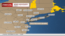
A strong cold front is sweeping through the tri-state through Friday afternoon and into the evening, bringing heavy rain, isolated thunderstorms and gusty winds — some of which could hit 50+ mph with a wind advisory up until midnight.
Storm warnings were issued for much central and northeastern New Jersey in the mid-afternoon, which later extended into New York City. Severe thunderstorm warnings were in effect for all five boroughs, New York’s Hudson Valley, plus Bergen, Essex Hudson and Union counties in New Jersey until 4:15 p.m.
Winds around 60 mph and hail can be expected as part of the storms. The strong winds can lead to flying debris and lead to power outages.
In the morning, wind gusts topped 60 mph in many parts of the tri-state. The highest was measured in Farmingville on Long Island, which saw 66 mph, though many counties saw wind speeds above 50 mph.
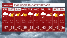
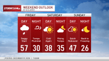
Temperatures started near record highs in the 50s, making the morning commute almost sweaty for anyone bundled up in a winter jacket. But those coats will be necessary Friday night, as temperatures tumble into the 20s. Drivers and pedestrians should watch for icy spots where any standing water from the earlier showers and melted snow can refreeze.
As the night goes on, skies clear out and winds grow calmer under high pressure.
The weekend will stay mostly dry but breezy, with a weak warm front late Saturday with warmer temperatures on Sunday for the winter solstice.
Monday turns frigid with highs in the low 30s, then a system Tuesday could bring a light mix of snow and rain before clearing midweek.
Another weak disturbance might show up around Christmas, but details are still fuzzy so stay tuned!