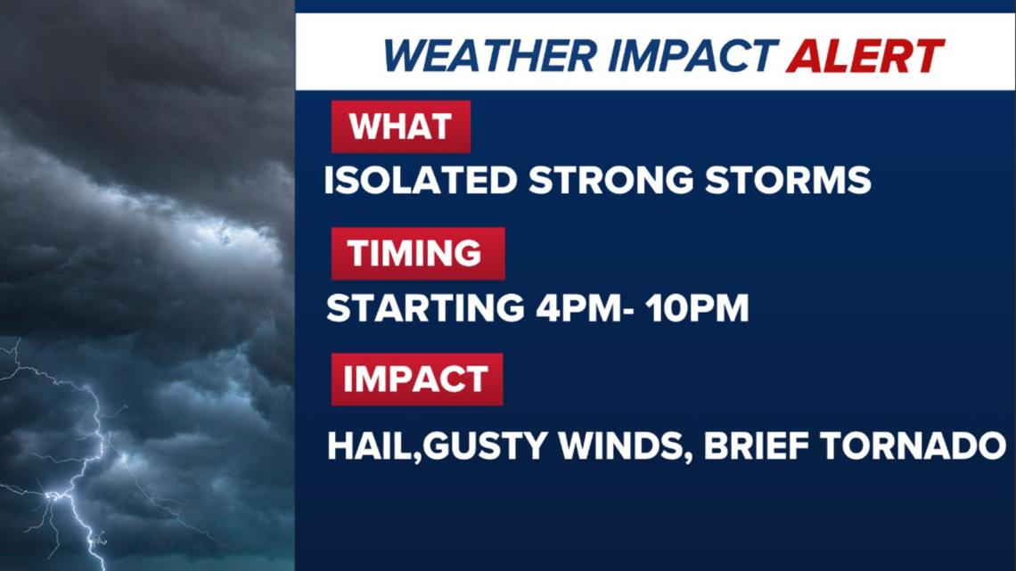
A Weather Impact Alert is in effect as storm chances increase this evening. Stronger storms are most likely north of Houston between 4 and 10 p.m.
HOUSTON — The KHOU 11 Weather Team has issued a Weather Impact Alert for this afternoon into tonight as isolated storms develop across Southeast Texas. While much of the day will be quiet, a few storms later today could turn strong, especially north of Houston.
Meteorologist Chita Craft says the severe weather threat increased overnight, prompting the alert.
Urgency & threat level
Although storms will not be widespread, any storm that becomes stronger could produce impacts quickly.
Possible threats include:
- Gusty winds (the primary concern)
- Hail
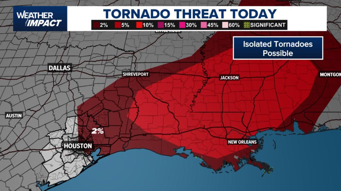
- A brief tornado (isolated)
Rain totals are expected to remain low overall, meaning flooding is not the main concern today. The focus is on wind impacts from stronger storms.

Timing: When storms are most likely
- Mostly quiet with isolated nuisance showers
- Light rain could create slick roads, but little accumulation is expected
- Still limited activity, though a brief downpour is possible in spots
Late afternoon to evening (4–10 p.m.)
- Isolated thunderstorms develop
- A few storms may strengthen, producing gusty winds or hail
- This is the main window for any severe weather locally
Late evening into midnight
- A cold front moves through
- Storm chances briefly increase again before clearing out quickly
The Weather Impact Alert currently runs from 4 p.m. to 10 p.m., though it could be extended later depending on storm evolution.

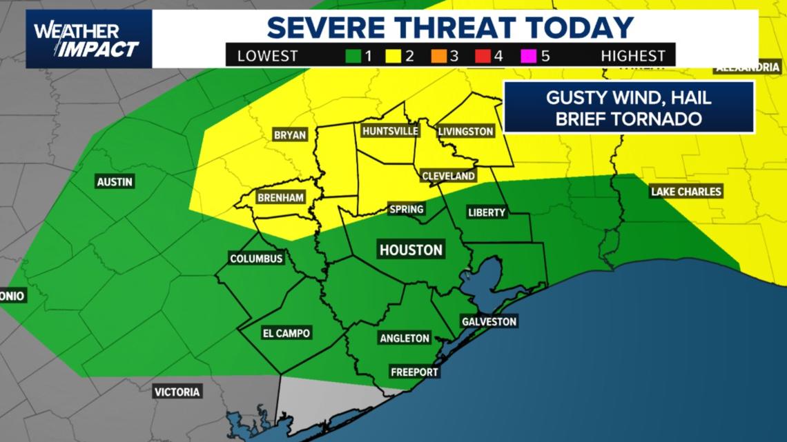
Areas impacted: Where the risk is highest
The highest risk for stronger storms is north of Houston, where storms are more likely to organize.
Areas to watch closely include:
- Montgomery County
- Walker County
- Northern Waller County
- Communities near Brenham, Bryan–College Station, Huntsville
- Parts of northwest Harris County, including Cypress, Jersey Village, The Woodlands, and Conroe
Houston, Galveston, and coastal communities remain at lower risk, though an isolated strong storm cannot be ruled out.
Farther east into Louisiana, storms are expected to become more intense later tonight.

Additional concerns: Fog and slick roads
Patchy fog and low cloud ceilings are already affecting parts of the area this morning.
- Visibility has dropped to around one mile or less in spots such as Pearland, Wharton, and Columbus
- While no Dense Fog Advisory is in effect, reduced visibility could slow the morning commute
- Light showers may also cause slick roadways, especially before sunrise
What you can do
- Stay weather-aware this evening, especially if you live north of Houston
- Secure lightweight outdoor items that could be affected by gusty winds
- Allow extra travel time this morning due to fog and slick roads
- Have multiple ways to receive weather alerts if storms approach your area
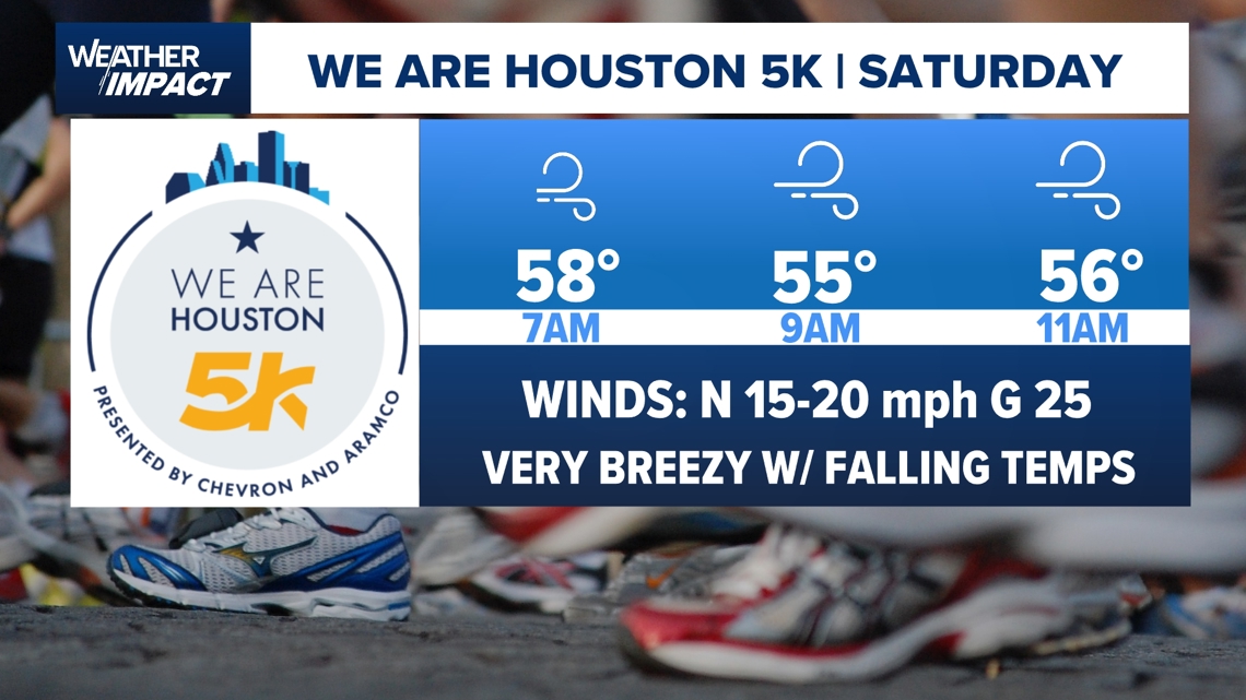
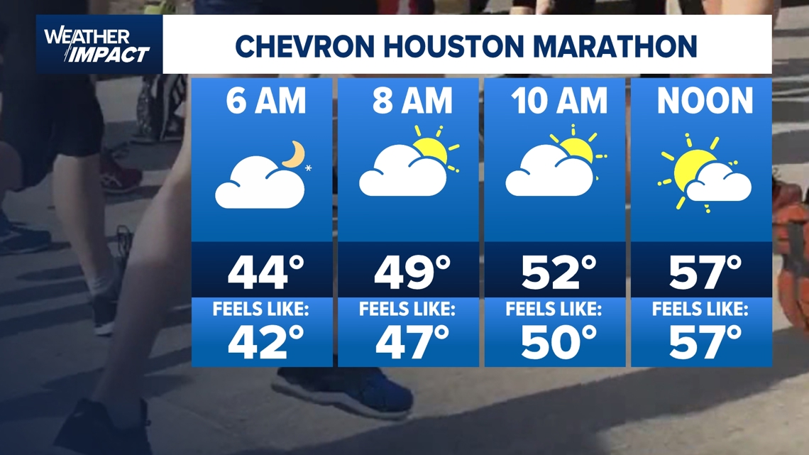
Marathon weekend forecast
The timing of the front couldn’t be better for runners.
- Race start: Around 44 degrees
- Winds: North at 5–10 mph
- Conditions: Cloud cover, dry, no heat or humidity
- Finish: Temperatures in the 50s
Forecasters say the forecast checks all the boxes for a comfortable race.


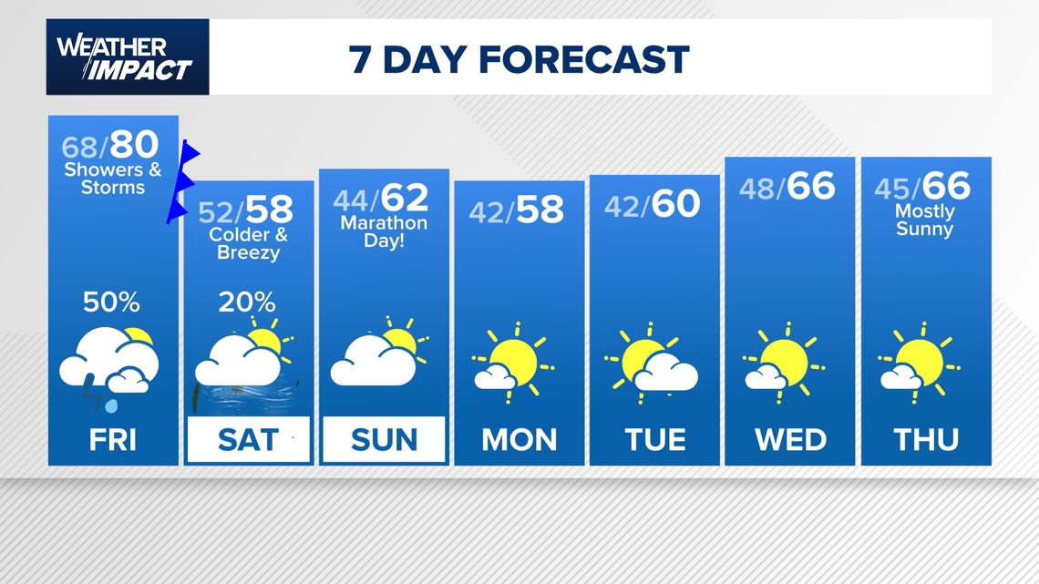
What is the extended 7-Day Forecast?
After our next cold front for Houston Marathon weekend, overnight and morning temperatures will remain in the 40s, so you will need a jacket if you are headed out the door. Afternoon highs will be in the 50s and 60s with occasional cloud cover. We will warm back into the upper 60s by Wednesday afternoon with mostly sunny skies.

Harris County (including Houston, Pasadena, Baytown), Fort Bend County (Richmond, Sugar Land, Missouri City), Montgomery County (Conroe, The Woodlands), Brazoria County (Angleton, Pearland, Alvin, Lake Jackson), Galveston County (Galveston, League City, Texas City), Liberty County (Liberty, Cleveland, Dayton), Walker County (Huntsville, New Waverly), Waller County (Hempstead, Prairie View, Waller), Polk County (Livingston, Corrigan), Chambers County (Anahuac, Mont Belvieu, Winnie), Wharton County (Wharton, El Campo), Washington County (Brenham), Matagorda County (Bay City, Palacios), Grimes County (Anderson, Navasota), Austin County (Bellville, Sealy), Colorado County (Columbus, Eagle Lake, Weimar), Trinity County (Groveton, Trinity).