
Tomorrow will be picture perfect before near record heat persists Sunday through Wednesday.
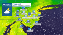
Tonight will be partly cloudy and pleasant with calm winds. Overnight lows will dip into the upper 40s and low 50s.
High pressure will provide wall to wall sunshine for all of our neighborhoods tomorrow with temperatures in the low 80s inland and upper 60s down the shore.
That same area of high pressure slides off shore to provide a stronger push of wind out of the south and southwest.

Therefore, Sunday will be much warmer, partly cloudy and a little humid. Highs on Sunday will reach near 90 inland and upper 70s to around 80 down the shore.
Hot and slightly humid conditions persist Monday through Wednesday with highs in the low to mid 90s.
A strong cold front will bring storms Wednesday evening and night.
Light rain lingers into Thursday morning. Thursday will be cooler, though seasonably so, with highs in the low 70s.