Heavy snow turns lighter by morning in Vermont, New York
The season’s biggest storm so far will arrive by Sunday afternoon
IN ESSEX JUNCTION, UNION, MARTINEZ, NBC FIVE NEWS NOW NBC5 CERTIFIED MOST ACCURATE FORECAST. AND THOSE CREWS THAT GENTLEMAN WAS TALKING ABOUT HAVE A LONG NIGHT OF WORK AHEAD OF THEM. YEAH. YOU KNOW IT’S INTERESTING FOR NORTHERN SPOTS THE SNOW IS VERY DRY. IT BLOWS OFF THE CAR. BUT THE FLAKES ARE NOT BIG YET. THEY’RE NOT PRETTY. SO IT’S NOT REALLY ADDING UP QUICK ENOUGH. HAD THAT REPORT OF ONE INCH IN FIVE HOURS LIKE OH MY GOSH, WHAT’S GOING ON WITH THE FORECAST. IT MAY BE LOWER END OF THE TOTALS NORTH AND THEN HIGHER SOUTH. SO DEFINITELY DEALING WITH THE COLD AIR. YOU KNOW, SOMETIMES IT CAN BE SO COLD THAT THE CLOUDS ARE NOT SATURATED. WE WOULD SAY THERE’S ALSO NOT A LOT OF RISING MOTION ACROSS NORTHERN NEW YORK AND NORTHERN VERMONT. SO I WOULD SAY LOWER END OF THE TOTALS NORTH. AND THEN RIGHT IN THE MIDDLE OF THE RANGES, AS YOU GO SOUTH, YOU’LL SEE THAT WHEN WE SEE THE MAP, BUT EVERYONE IS GETTING THE SNOW RIGHT NOW, JUST NOT ADDING UP SUPER FAST. TO THE NORTH. THERE’S THE LOW. IT’S OFF OF DELAWARE AND GOING EAST. IT’S NOT A CLASSIC BOMBOGENESIS SITUATION. THAT WOULD BE A BLIZZARD BECAUSE THERE WOULD BE WIND. THERE’S NOT A LOT OF WIND WITH THIS STORM. SO GOOD SHAPE IN THAT REGARD. SO THE SNOW IS HEAVIEST THIS EVENING. POWDER SNOW. FORGOT A LITTLE D IN THERE. THE POWDER SNOW HEAVIEST THIS EVENING EIGHT INCHES FOR NORTHERN AREAS A FOOT IN THE MIDDLE LIKE WASHINGTON COUNTY VERMONT 18IN FOR THE SOUTHERN MOUNTAINS. I THINK THAT’S THE SIMPLEST WAY TO BREAK IT DOWN. LIGHTER SNOW LINGERS FOR TOMORROW. THIS MAP REALLY TELLS THE STORY WITH MORE OF A LESSER IMPACT. NEAR NEWPORT AND MALONE MINOR ON THE NATIONAL WEATHER SERVICE WINTER STORM SEVERITY INDEX, BUT MORE OF A MAJOR IMPACT AS YOU GO SOUTH. EXTREME FOR THE NORTH SHORE AND BOSTON IN MASSACHUSETTS. NOW THIS IS OUTSIDE THE STATION IN SOUTH BURLINGTON. WE’VE GOT THE SNOW FALLING RIGHT NOW. IT’S ONLY FIVE. IT’S PRETTY RARE TO HAVE A SNOWSTORM WHEN IT’S THIS COLD. ACROSS THE BOARD, YOU SEE THE HIGHWAYS A MESS, ESPECIALLY FROM CENTRAL VERMONT POINT SOUTH WHERE THERE’S BEEN A LITTLE BIT MORE INTENSITY WITH THE SNOW. AND SO MATT DILORETO IN THE WEATHER LAB HAS BEEN GOING SOUTH ON ROUTE SEVEN TO TRY TO FIND SOME OF THOSE HEAVIER RATES. LET’S SEE HOW THINGS ARE LOOKING OUT THERE RIGHT NOW. MATT, I REALLY DO THINK NORTH IT’S GOING TO BE THE LOWER END OF THESE THESE RANGES RIGHT? YEAH. TYLER, THAT SEEMS MOST LIKELY BECAUSE THE TYPE OF SNOWFLAKE WE WERE SEEING WITH THE SNOW WAS LIGHTER. AND AS YOU PUSH NEAR THE CANADIAN BORDER WAS MORE THEIR COLLECTION OF PLATES AND NEEDLES, WE CALL THEM THE REAL ICY KIND OF SNOWFLAKES THAT FALL. BUT WE HAVE PUSHED SOUTH INTO FERRISBURG, INTO SOME OF THE HEAVIER BANDS. AND I JUST WANT TO SHOW YOU THE SNOWFLAKE GROWTH HAS BEEN MUCH BETTER ONCE THE RATES GET HEAVIER. AND THAT’S BECAUSE THE SNOW GROWTH ZONE IN THE CLOUDS, WHERE THE SNOWFLAKES FORM IS TOTALLY SATURATED, AND THAT ALLOWS THOSE FLAKES TO FORM WITH A LOT OF AIR IN BETWEEN. SO THEY’RE MUCH FLUFFIER AND THEY’RE COMING DOWN A LOT HARDER. THE TEMPERATURE IS STILL FIVE DEGREES. WE ARE PULLED OFF THE SIDE OF ROUTE SEVEN RIGHT NOW AT A GAS STATION, AND NO MORE PAVEMENT SHOWING UP ON THE ROADS. THE SNOW IS KIND OF PICKED UP IN INTENSITY ENOUGH SO THAT WE’RE SEEING A SNOW PACKED ROAD. THE ONLY SAVING GRACE IS THAT DRY SNOW TENDS TO BE A LITTLE BIT, OR HAVE A LITTLE BIT MORE TRACTION THAN, SAY, THE WET AND GREASY SNOW YOU WOULD GET. AND WE’RE NOT SEEING A MELTING AND REFREEZING SITUATION WITH THE SNOWFLAKES UNDER THE LAYER OF SNOW, BECAUSE AT THESE TEMPERATURES, SALT IS JUST NOT THAT EFFECTIVE IN MELTING THE SNOW. SO IT’S ALMOST BETTER IF YOU PUT SAND DOWN AND GAIN A LITTLE EXTRA TRACTION. YOU SEE THE 18 WHEELERS JUST CREEPING RIGHT UP TO THE LIGHT THERE. IT IS A RED LIGHT, BUT TRAFFIC HAS BEEN MOVING PRETTY STEADILY. I THINK THINGS TYLER, THOUGH, WILL START TO GO DOWNHILL AS WE GO THROUGH THE REST OF THIS EVENING. WHAT DO YOU THINK? YEAH, THANK YOU FOR THAT. WE’LL CHECK IN WITH YOU A LITTLE LATER ON. DEFINITELY A HEAVIER SNOWSTORM TO THE SOUTH. IT’S FRIGID JUST ABOVE OR BELOW ZERO, DEPENDING ON WHERE YOU ARE. MINUS ONE IN MONTPELIER. HERE’S THE HEAVIER SNOW THROUGH THIS EVENING UNTIL ABOUT TWO IN THE MORNING. MUCH, MUCH LIGHTER BY TOMORROW MORNING. SO IT’S FINE TO SHOVEL AND PLOW IN THE MORNING JUST SO THERE’S A LITTLE BIT MORE TO COME DURING THE DAY TOMORROW. MAYBE SAY 2 TO 4IN DURING THE DAY TOMORROW. THAT NUMBER IS FACTORED INTO OUR STORM TOTALS. BUT JUST IN CASE YOU’RE WONDERING HOW MUCH MORE COMES DURING THE DAY, IT’S ONLY A LITTLE BIT. AND THEN WE MIX IN SUNSHINE WITH SNOW SHOWERS ON TUESDAY. SHOULDN’T BE TOO MUCH OF A PROBLEM TUESDAY. SO AGAIN, LOWER END OF THE RANGES NORTH. THAT MEANS ABOUT EIGHT INCHES FOR THE WHOLE STORM IN MALONE AND ROUSES POINT IN NEWPORT. THAT WILL DO. THEN YOU GO SOUTH, MAYBE 8 OR 9 IN BURLINGTON. SAME DEAL IN MIDDLEBURY. RUTLAND COULD BE LIKE TEN INCHES, BUT REALLY YOU GOT TO GO TO SOUTHERN ESSEX COUNTY NEAR NORTH HUDSON AND SCHROON LAKE TO GO PAST A FOOT. SAME DEAL FOR THE MAD RIVER VALLEY. WASHINGTON COUNTY, 12IN. COULD BE MORE THAN THAT BY A LITTLE BIT, BUT REALLY, THE VERMONT BULL’S-EYE IS HERE. LUDLOW LONDONDERRY. AND THEN DOVER. THIS IS A TWO FOOT ZONE. THE FLAKES ARE GOING TO BE NICER DOWN THERE. THERE’S MORE RISING MOTION IN THE ATMOSPHERE, AND YOU REALLY NEED THAT FOR THE BIG FLAKES THAT ADD UP QUICKLY. SO I THINK IT’S A SOUTHERN THING FOR THE MOST SNOW AS WE GO THROUGH TOMORROW, TEMPERATURES COME UP INTO THE TEENS. HOW ABOUT THAT? FEELS BETTER. AND ROADS IMPROVE. BUT AGAIN, STILL PRETTY INEFFECTIVE FOR SALT WITH 17 FOR THE HIGH. A COUPLE SNOW SHOWERS TUESDAY AND THEN WE GET A WEATHER BREATHER FOR THE REST OF THE MONTH. NOW IT’S STILL COLD, BUT THERE’S NO STORMS IN THERE FOR THE REST OF J
NBC5 First Warning Chief Meteorologist
Heavy snow continues tonight with rapid accumulation in southern Vermont.Temperatures remain in the single digits above and below zero.The powder snow will continue into Monday, with lighter intensity north and heavy intensity south. Impacts to schools, businesses, etc. are certain on Monday, as hundreds of schools are already closed as of 6 p.m. Sunday. Early Monday morning, the snow turns lighter for everyone. Storm total accumulation will be near 8 inches along the Canadian border, with 12 to 18 inches for central Vermont, and 24 inches in the mountains of southern Vermont. Given the light weight of the snow, power outages are not expected from snow loading. The rest of the month stays mostly dry, but it is consistently very cold! Want more local news? Download our NBC5 mobile app for iOS and Android.STAY WEATHER-AWAREFor the latest weather coverage for your area, click here. Stay updated with alerts in the myNBC5 app, which you can download here.For the best weather information and Vermont and northern New York’s Certified Most Accurate forecast, watch NBC5 News by streaming at this link.Don’t forget to follow NBC5 News on Facebook, X (formerly Twitter), and Instagram.Follow the NBC5 First Warning Weather team on social media:Chief Meteorologist Tyler Jankoski Facebook | X | InstagramMeteorologist Ben Frechette Facebook | X | InstagramMeteorologist Matt DiLoreto Facebook | XMeteorologist Andrew Grautski Facebook | XMeteorologist Marissa Vigevani Facebook | X
SOUTH BURLINGTON, Vt. —
Heavy snow continues tonight with rapid accumulation in southern Vermont.
Temperatures remain in the single digits above and below zero.

NBC5 News
The height of the storm occurs Sunday night across northern New England and New York.
The powder snow will continue into Monday, with lighter intensity north and heavy intensity south. Impacts to schools, businesses, etc. are certain on Monday, as hundreds of schools are already closed as of 6 p.m. Sunday.
Early Monday morning, the snow turns lighter for everyone.

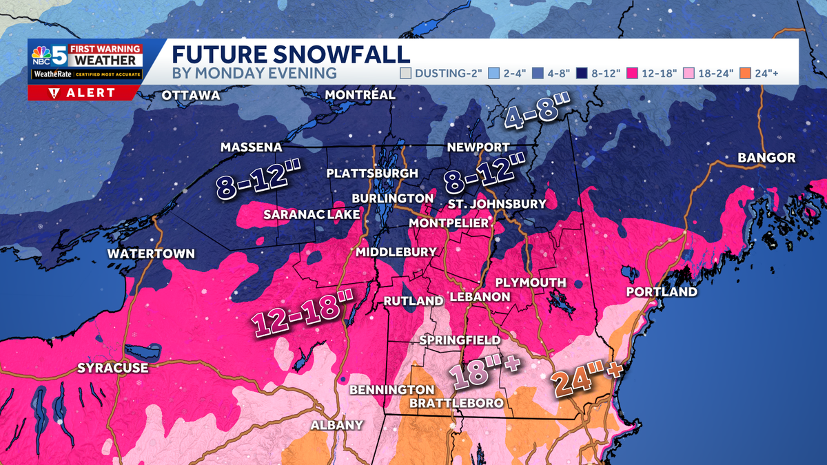
Storm total accumulation will be near 8 inches along the Canadian border, with 12 to 18 inches for central Vermont, and 24 inches in the mountains of southern Vermont.
Given the light weight of the snow, power outages are not expected from snow loading.

Hearst Owned
Our latest extended forecast.
The rest of the month stays mostly dry, but it is consistently very cold!
Want more local news? Download our NBC5 mobile app for iOS and Android.
STAY WEATHER-AWARE
For the latest weather coverage for your area, click here. Stay updated with alerts in the myNBC5 app, which you can download here.
For the best weather information and Vermont and northern New York’s Certified Most Accurate forecast, watch NBC5 News by streaming at this link.
Don’t forget to follow NBC5 News on Facebook, X (formerly Twitter), and Instagram.
Follow the NBC5 First Warning Weather team on social media: